

-

Originally Posted by
TheRef

I wouldn't trust the ECMWF right now due to the horrible initialization.
This was latest from NHC. Granted it was at only 2mph.
-
Originally Posted by
starkvegasdawg34
This was latest from NHC. Granted it was at only 2mph.
Oh I know. I wasn't saying that what you said was wrong. Just saying that if you were thinking about trusting the ECMWF, don't.
B.S. Geosciences, Professional Meteorology Concentration, Operational Emphasis
c/o 2015
Mississippi State University
@ColdSouthern911
Leicester City FC Owner
-
The way these models have missed so much on this storm I'm not even looking at them any more.
-
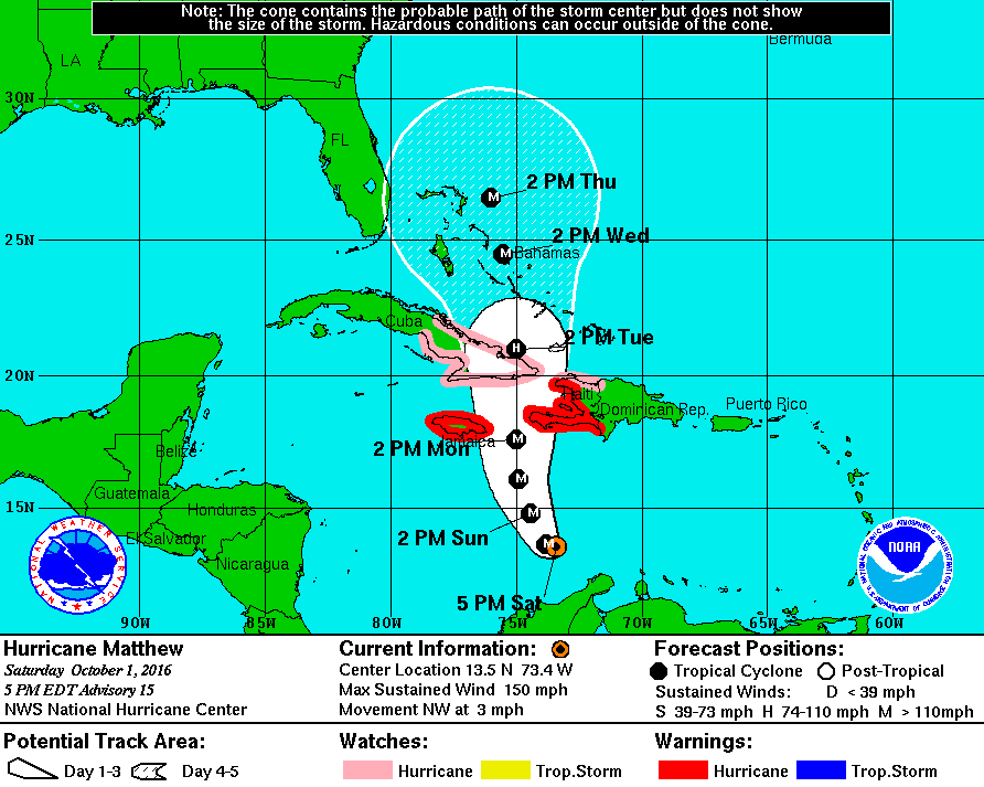
Hurricane Matthew got stronger. Now 150 MPH winds at the surface and he has made the turn towards the North. Gitmo being evacuated of all non-essential personnel.
B.S. Geosciences, Professional Meteorology Concentration, Operational Emphasis
c/o 2015
Mississippi State University
@ColdSouthern911
Leicester City FC Owner
-
Originally Posted by
TheRef
Hurricane Matthew got stronger. Now 150 MPH winds at the surface and he has made the turn towards the North. Gitmo being evacuated of all non-essential personnel.
Wonder what they'll do with the terrorists? Are they essential?
-
Originally Posted by
RocketDawg
Wonder what they'll do with the terrorists? Are they essential?
Solitary confinement for EVERYBODYYYYYYY
B.S. Geosciences, Professional Meteorology Concentration, Operational Emphasis
c/o 2015
Mississippi State University
@ColdSouthern911
Leicester City FC Owner
-
Originally Posted by
RocketDawg
Wonder what they'll do with the terrorists? Are they essential?
I say lock em all in the rec yard cages.
-
Originally Posted by
starkvegasdawg34
I say lock em all in the rec yard cages.
Nah use it as an interrogation technique.
"If you don't tell us where the leaders are, we are putting you out in the Hurricane"
B.S. Geosciences, Professional Meteorology Concentration, Operational Emphasis
c/o 2015
Mississippi State University
@ColdSouthern911
Leicester City FC Owner
-
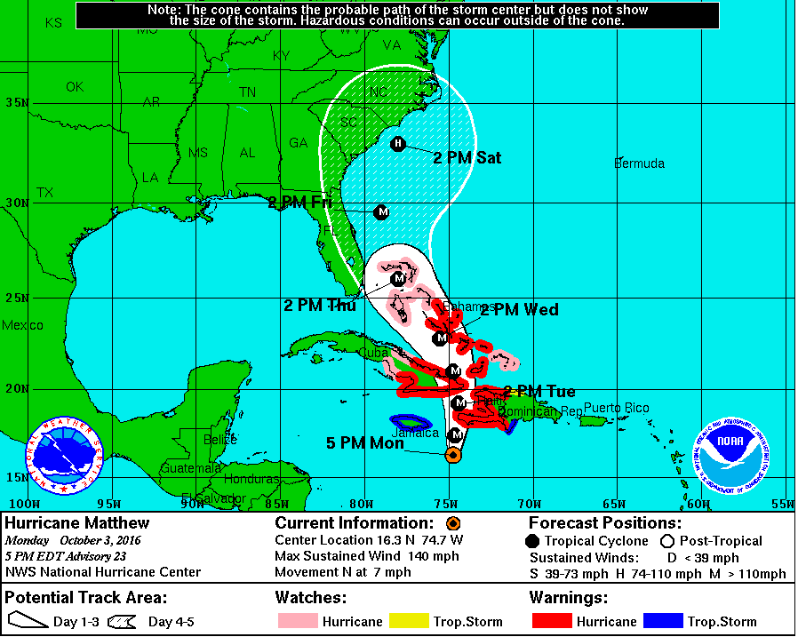
Models are trending Matthew further and further West, which makes a US landfall much more likely. Could spell danger for Florida/Georgia if models end up verifying
-
Senior Member

Last edited by spbdawg; 11-26-2018 at 11:45 AM.
-
Originally Posted by
RocketDawg
Wonder what they'll do with the terrorists? Are they essential?
The Three Tides for them
-
Originally Posted by
spbdawg
Any updates? I'm travelling to Key West Friday am but flying into Ft. Lauderdale and driving down. Am I screwed?
You will want to watch this very closely. Current forecast track would be a glancing blow at best on Ft. Lauderdale Thursday, but one of the model ensembles is showing a growing mthreat for FL. This storm has had a mind of its own from the outset.
-
Still holding steady with 140mph. One change is models are still trending track further west. Bahamas look to take a direct hit and eastern FL needs to be especially alert.
-
Gonna be a beast regardless when it makes landfall. The only thing keeping Matthew from getting even stronger is the blob connected to the East side of the storm

B.S. Geosciences, Professional Meteorology Concentration, Operational Emphasis
c/o 2015
Mississippi State University
@ColdSouthern911
Leicester City FC Owner
-
Looks like the blob is disappearing.
-
Things change but look at NC. Damn I'm hoping for a miss!
-
Originally Posted by
starkvegasdawg34
Looks like the blob is disappearing.
Hispanola will hate the Blob.
B.S. Geosciences, Professional Meteorology Concentration, Operational Emphasis
c/o 2015
Mississippi State University
@ColdSouthern911
Leicester City FC Owner
-
Originally Posted by
TheRef
Models are trending Matthew further and further West, which makes a US landfall much more likely. Could spell danger for Florida/Georgia if models end up verifying
NOOO!!! Now I'm inside the cone of death. Guess football Friday night will be a little wet.
-
Originally Posted by
BrunswickDawg
NOOO!!! Now I'm inside the cone of death. Guess football Friday night will be a little wet.
Cone of probability. Also, they are not forecasting Matthew to be stronger than a Cat 2 at landfall.
B.S. Geosciences, Professional Meteorology Concentration, Operational Emphasis
c/o 2015
Mississippi State University
@ColdSouthern911
Leicester City FC Owner
-
Latest advisory has Matthew strengthening. Pressure down to 934mb and winds up to 145mph.
 Posting Permissions
- You may not post new threads
- You may not post replies
- You may not post attachments
- You may not edit your posts
-
Forum Rules
Disclaimer: Elitedawgs is a privately owned and operated forum that is managed by alumni of Mississippi State University. This website is in no way affiliated with the Mississippi State University, The Southeastern Conference (SEC) or the National Collegiate Athletic Association (NCAA). The views and opinions expressed herein are strictly those of the post author and may not reflect the views of other members of this forum or elitedawgs.com. The interactive nature of the elitedawgs.com forums makes it impossible for elitedawgs.com to assume responsibility for any of the content posted at this site. Ideas, thoughts, suggestion, comments, opinions, advice and observations made by participants at elitedawgs.com are not endorsed by elitedawgs.com
Elitedawgs: A Mississippi State Fan Forum, Mississippi State Football, Mississippi State Basketball, Mississippi State Baseball, Mississippi State Athletics. Mississippi State message board.


 Reply With Quote


