

-
Junior Member

Following this thread. This storm is fascinating to watch. When do you think it will make that turn? Are you a believer of the Hebert Box?
-

Originally Posted by
msstate7

Do they build big hurricane shelters for the public?
No they don't. Not enough money to do so.
B.S. Geosciences, Professional Meteorology Concentration, Operational Emphasis
c/o 2015
Mississippi State University
@ColdSouthern911
Leicester City FC Owner
-
Originally Posted by
FleaFlicker
Following this thread. This storm is fascinating to watch. When do you think it will make that turn? Are you a believer of the Hebert Box?
It is already slowing down as it is finding the weak spot in the high pressure. It should really start moving north in the next 48 hours or so. The Hebert Box, while present, is only a tool in predicting the landfall possibility. Hebert even said himself that it is not a tried and true indicator that a storm will hit Florida. Basically the basis for the boxes is that the storms will miss Cuba on its way to landfall. The portion of Cuba that Matthew will have to travel through is pretty mountainous, it is also the largest land mass of Cuba it will have to go through. So Cuba and Jamaica together will strongly decrease the strength of Matthew.
B.S. Geosciences, Professional Meteorology Concentration, Operational Emphasis
c/o 2015
Mississippi State University
@ColdSouthern911
Leicester City FC Owner
-
Junior Member
Originally Posted by
TheRef
It is already slowing down as it is finding the weak spot in the high pressure. It should really start moving north in the next 48 hours or so. The Hebert Box, while present, is only a tool in predicting the landfall possibility. Hebert even said himself that it is not a tried and true indicator that a storm will hit Florida. Basically the basis for the boxes is that the storms will miss Cuba on its way to landfall. The portion of Cuba that Matthew will have to travel through is pretty mountainous, it is also the largest land mass of Cuba it will have to go through. So Cuba and Jamaica together will strongly decrease the strength of Matthew.
Thank you for that explanation. I haven't had time to look it up since i first saw it today. Fascinating stuff!!
-
Originally Posted by
FleaFlicker
Thank you for that explanation. I haven't had time to look it up since i first saw it today. Fascinating stuff!!
Constantly changing weather like that is quite fascinating. We're always trying to get better with track and intensity on tropical cyclones. The problem we are having is the fact that very subtle changes can dramatically change large systems like this.
B.S. Geosciences, Professional Meteorology Concentration, Operational Emphasis
c/o 2015
Mississippi State University
@ColdSouthern911
Leicester City FC Owner
-
Originally Posted by
TheRef
Cuba and Jamaica together will strongly decrease the strength of Matthew.
Meh, It happens. 
-
Officially a cat 5 with 160mph winds. Indications it may still be getting stronger. This is borderline unprecedented stenghening.
-
Originally Posted by
starkvegasdawg34
Officially a cat 5 with 160mph winds. Indications it may still be getting stronger. This is borderline unprecedented stenghening.
I read it could be the worst storm in Jamaican history. Worse than Gilbert in 88. I don't remember that storm because i was a little guy but worst storm in 30 years don't sound good.
-
Originally Posted by
BeastMan
I read it could be the worst storm in Jamaican history. Worse than Gilbert in 88. I don't remember that storm because i was a little guy but worst storm in 30 years don't sound good.
Gilbert was only a Category 3 and landfall on Jamaica. Then Gilbert strengthened again to Cat 5 after passing Jamaica.
B.S. Geosciences, Professional Meteorology Concentration, Operational Emphasis
c/o 2015
Mississippi State University
@ColdSouthern911
Leicester City FC Owner
-
Any chance we'll get some rain out of this storm? We really need some bad.
-
Originally Posted by
InTheIttaBenaHotSun
Any chance we'll get some rain out of this storm? We really need some bad.
Ain't looking good. If it makes its expected turn north we won't see any type of impact from it.
-
Senior Member
I'm in charge of offshore gas operations in LaGuajira district Colombia (Riohacha & Ballena). It's the northern tip of Colombia. So far, we've had a good bit of rain, some road flooding, but otherwise not much impact. Ready for it to turn north... But praying for the people of Jamaica.
-
Originally Posted by
starkvegasdawg34
Officially a cat 5 with 160mph winds. Indications it may still be getting stronger. This is borderline unprecedented stenghening.
What was the one that went from nothing to a Cat 5 virtually overnight before striking Belize? That had to be the fastest strengthening storm ever on the Atlantic side.
-
Originally Posted by
RocketDawg
What was the one that went from nothing to a Cat 5 virtually overnight before striking Belize? That had to be the fastest strengthening storm ever on the Atlantic side.
Mitch or Dean? Not sure.
-
Originally Posted by
starkvegasdawg34
Ain't looking good. If it makes its expected turn north we won't see any type of impact from it.
You guys need to put in an order for some rain. Dry as heck around here.
-
Hate to say it but none of the long term models are showing any rain. Next 10-17 days may be a little arid if things hold. At least your yard won't need mowing.
-
Originally Posted by
TheRef
You may want to watch out for Hurricane Matthew that's spinning south of Hispanola. He is a Category 3 Hurricane right now, and is expected to strengthen further before making landfall in Jamaica. Matthew is getting the benefit of untouched waters to build and intensify. Current tracks have Matthew missing the Gulf of Mexico, due to a cutoff Low Pressure center over the middle of the country. Now the model guidance does not have landfall coming to Florida currently, but this could change within the next 3-4 days depending on the track Matthew takes through Jamaica and Cuba. Needless to say, the whole Eastern seaboard needs to be watching this system closely.
Need a decent tropical storm to come over my hunting land so I can plant some food plots
Not only did Mississippi State embarrass LSU on this night. Davis Wade Stadium wrecked Tiger Stadium in music choice, atmosphere and, most of all, volume.
When I'm 80 and deaf, it's not going to be all those Springsteen concerts or Queen at Municipal Auditorium in New Orleans on Halloween Night in 1978, it will be this game...............Glen Guilbeau--Sherveport Times
-
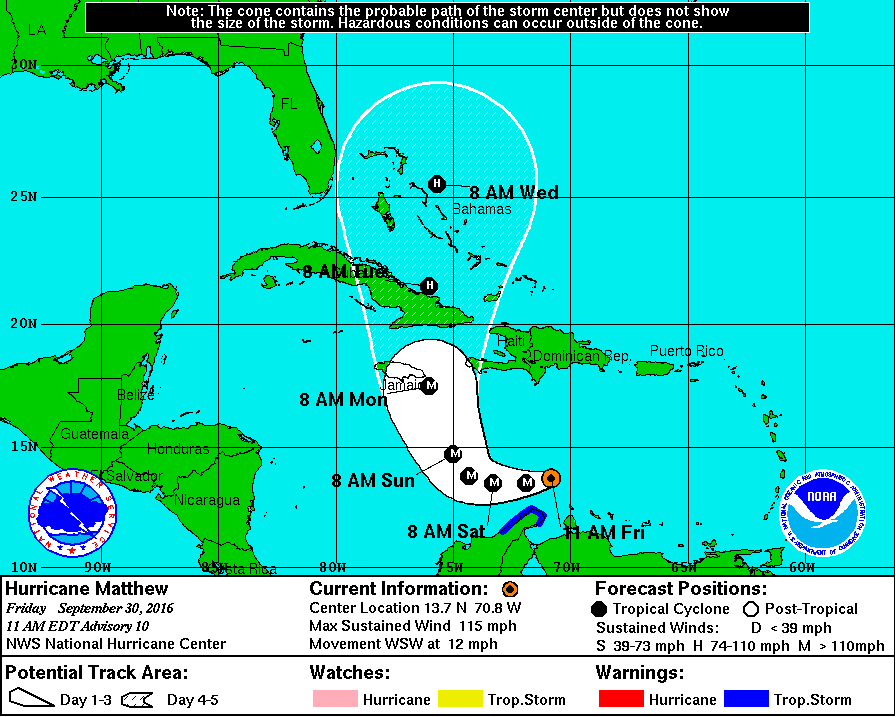
Latest cone of probability from NHC
B.S. Geosciences, Professional Meteorology Concentration, Operational Emphasis
c/o 2015
Mississippi State University
@ColdSouthern911
Leicester City FC Owner
-
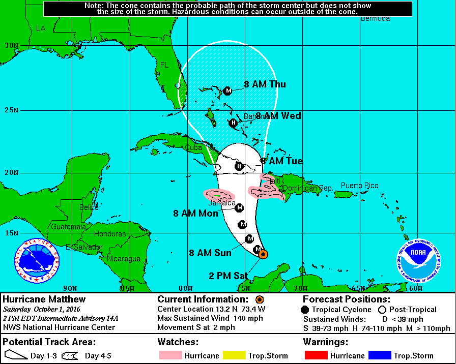
Latest update has it moving due south.
-
Originally Posted by
starkvegasdawg34
Latest update has it moving due south.
I wouldn't trust the ECMWF right now due to the horrible initialization.
B.S. Geosciences, Professional Meteorology Concentration, Operational Emphasis
c/o 2015
Mississippi State University
@ColdSouthern911
Leicester City FC Owner
 Posting Permissions
- You may not post new threads
- You may not post replies
- You may not post attachments
- You may not edit your posts
-
Forum Rules
Disclaimer: Elitedawgs is a privately owned and operated forum that is managed by alumni of Mississippi State University. This website is in no way affiliated with the Mississippi State University, The Southeastern Conference (SEC) or the National Collegiate Athletic Association (NCAA). The views and opinions expressed herein are strictly those of the post author and may not reflect the views of other members of this forum or elitedawgs.com. The interactive nature of the elitedawgs.com forums makes it impossible for elitedawgs.com to assume responsibility for any of the content posted at this site. Ideas, thoughts, suggestion, comments, opinions, advice and observations made by participants at elitedawgs.com are not endorsed by elitedawgs.com
Elitedawgs: A Mississippi State Fan Forum, Mississippi State Football, Mississippi State Basketball, Mississippi State Baseball, Mississippi State Athletics. Mississippi State message board.


 Reply With Quote


