

-
2/23/2016 Severe Weather Thread
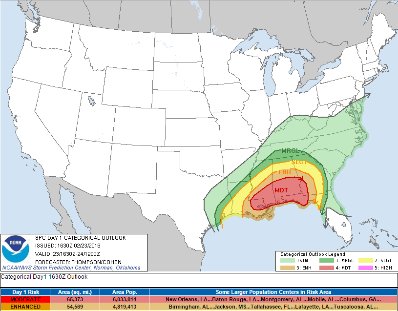
So today just got a little bit more interesting. They just expanded the Moderate Risk area, and we already have a Tornado Warning in Louisiana.
B.S. Geosciences, Professional Meteorology Concentration, Operational Emphasis
c/o 2015
Mississippi State University
@ColdSouthern911
Leicester City FC Owner
-
A closer look at the risk areas...

B.S. Geosciences, Professional Meteorology Concentration, Operational Emphasis
c/o 2015
Mississippi State University
@ColdSouthern911
Leicester City FC Owner
-
Think we are going to Hburg to monitor.
-
Tornado Watch in effect until 5 PM CST

B.S. Geosciences, Professional Meteorology Concentration, Operational Emphasis
c/o 2015
Mississippi State University
@ColdSouthern911
Leicester City FC Owner
-
Funnel Cloud/possible tornado visible from New Orleans International Airport tower...how would you like to call that in?
B.S. Geosciences, Professional Meteorology Concentration, Operational Emphasis
c/o 2015
Mississippi State University
@ColdSouthern911
Leicester City FC Owner
-
You feel like anything to worry about in jackson area?
-

Originally Posted by
confucius say

You feel like anything to worry about in jackson area?
High winds and hail...isolated tornado
B.S. Geosciences, Professional Meteorology Concentration, Operational Emphasis
c/o 2015
Mississippi State University
@ColdSouthern911
Leicester City FC Owner
-
Senior Member


Come on down to the Burg!!!
-
Senior Member

damage to rental car facility at the airport
Originally Posted by
TheRef
Funnel Cloud/possible tornado visible from New Orleans International Airport tower...how would you like to call that in?
Those supercells are moving very fast. Reminds me of some of the supercells in Alabama in 2012.
I'm now in Hattiesburg. It looks like we might start getting some of these supercells moving through Hattiesburg earlier than expected. I think by 1:00.
-
Steve Caparotta @SteveWAFB 2m2 minutes ago
@NWSNewOrleans reporting damage to a rental car facility at @NO_Airport from a possible #tornado. #LAwx
-
Lake Ponchartrain Causeway Bridge won't be fun to drive on soon....the rotation that had that tornado is heading towards it now....hope everyone is safe.
B.S. Geosciences, Professional Meteorology Concentration, Operational Emphasis
c/o 2015
Mississippi State University
@ColdSouthern911
Leicester City FC Owner
-
NWS New Orleans @NWSNewOrleans 3m3 minutes ago
Possible waterspout from storm over the lake seen on causeway camera moments ago #LAwx #NOLAwx

-
Originally Posted by
TheRef
Lake Ponchartrain Causeway Bridge won't be fun to drive on soon....the rotation that had that tornado is heading towards it now....hope everyone is safe.
Truthful answer, what's the level of concern for the Meridian area? Be on alert, or get ready to duck?
-
Senior Member
Originally Posted by
Pollodawg
Truthful answer, what's the level of concern for the Meridian area? Be on alert, or get ready to duck?
They are the northern extent of the moderate risk area. So......
-
Senior Member
Wind is really getting gusty up 49 from Gulfport to Hattiesburg.
-
Senior Member
I'm more worried about these singular cells out ahead of the dry line than I am about the actual line/broken line.
As I speak, live video of 2 waterspouts over Lake Ponchatrain in Louisiana. Now 3. Unreal
-
Originally Posted by
ghostofjackie
I'm more worried about these singular cells out ahead of the dry line than I am about the actual line/broken line.
As I speak, live video of 2 waterspouts over Lake Ponchatrain in Louisiana. Now 3. Unreal
As you should..those are the the bigger threats to start spinning.
Yep..here is a pic of it..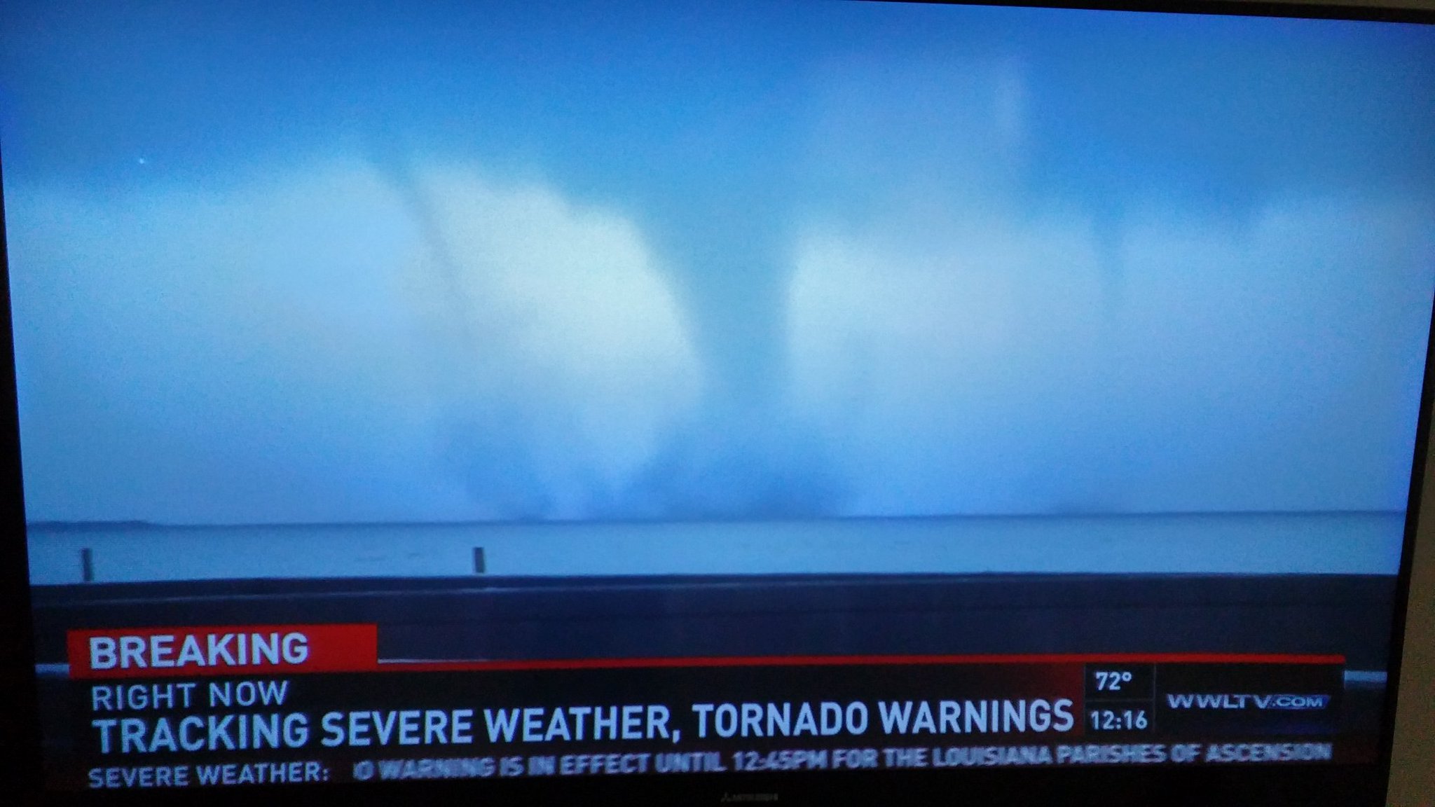
-
Senior Member
I've had WWL on. The chick reporter said that it lifted as it hit land, which I think is untrue and a irresponsible thing to report. When waterspouts hit land they change color because they are no longer lifting water into the air. That thing was on the ground and we will start getting damage reports on land soon to prove my point.
-
Watch it live here: Live Chasers
-
Tornado on the ground heading towards Livingston. Crossing I-12
B.S. Geosciences, Professional Meteorology Concentration, Operational Emphasis
c/o 2015
Mississippi State University
@ColdSouthern911
Leicester City FC Owner
 Posting Permissions
- You may not post new threads
- You may not post replies
- You may not post attachments
- You may not edit your posts
-
Forum Rules
Disclaimer: Elitedawgs is a privately owned and operated forum that is managed by alumni of Mississippi State University. This website is in no way affiliated with the Mississippi State University, The Southeastern Conference (SEC) or the National Collegiate Athletic Association (NCAA). The views and opinions expressed herein are strictly those of the post author and may not reflect the views of other members of this forum or elitedawgs.com. The interactive nature of the elitedawgs.com forums makes it impossible for elitedawgs.com to assume responsibility for any of the content posted at this site. Ideas, thoughts, suggestion, comments, opinions, advice and observations made by participants at elitedawgs.com are not endorsed by elitedawgs.com
Elitedawgs: A Mississippi State Fan Forum, Mississippi State Football, Mississippi State Basketball, Mississippi State Baseball, Mississippi State Athletics. Mississippi State message board.


 Reply With Quote


