-
Senior Member


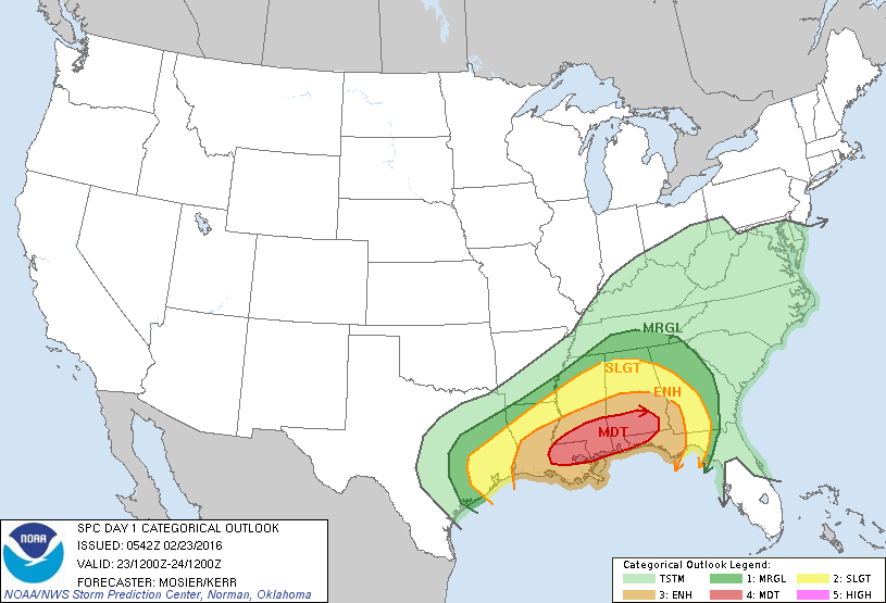
Are coastal counties going to be included in this threat area??
-

Originally Posted by
Hattdawg

Are coastal counties going to be included in this threat area??
Yes. All coastal counties are included in the Moderate Risk area provided by SPC. Will they be included in watches tomorrow? More than likely given the model consensus.
B.S. Geosciences, Professional Meteorology Concentration, Operational Emphasis
c/o 2015
Mississippi State University
@ColdSouthern911
Leicester City FC Owner
-
To be honest, guys. I don't think we play tomorrow...at all
B.S. Geosciences, Professional Meteorology Concentration, Operational Emphasis
c/o 2015
Mississippi State University
@ColdSouthern911
Leicester City FC Owner
-
B.S. Geosciences, Professional Meteorology Concentration, Operational Emphasis
c/o 2015
Mississippi State University
@ColdSouthern911
Leicester City FC Owner
-
-
ANYWHERE in that moderate risk area needs to be weather aware. This has a very real potential to be very bad this afternoon and early tonight.
-
Senior Member
I'm headed to Gulfport now and I live in Oak Grove, so yeah we are nervous. Schools letting out at 10:45.
-
I'm leaving to head down to that area around 10:00 this morning. Nothing has changed this morning to change my mind on the potential of this storm. Everything is coming together for a very bad day. Take ALL warnings for your area very seriously. Yes, some may have proven false in the past and some may be today - but a lot will be real and they will be for violent tornadoes. This is the kind of system where EF3 and EF-4 storms will be very likely. And yes, an EF-5 wouldn't shock me today. The shear today is just scary.
-
Senior Member

Originally Posted by
starkvegasdawg
I'm leaving to head down to that area around 10:00 this morning. Nothing has changed this morning to change my mind on the potential of this storm. Everything is coming together for a very bad day. Take ALL warnings for your area very seriously. Yes, some may have proven false in the past and some may be today - but a lot will be real and they will be for violent tornadoes. This is the kind of system where EF3 and EF-4 storms will be very likely. And yes, an EF-5 wouldn't shock me today. The shear today is just scary.
This.
Four ingredients you need for severe weather:
Moisture
Instability
Lift
Shear
All four there, the shear is crazy for LA/MS/AL , be safe, heed warnings, have a plan now.
-
Senior Member

No reason to be nervous
Originally Posted by
Hattdawg
I'm headed to Gulfport now and I live in Oak Grove, so yeah we are nervous. Schools letting out at 10:45.
Just make sure you stay weather aware and know where you are going to go in the event that a tornado comes near you. This isn't our first rodeo in South Mississippi and it won't be our last.
The conditions today remind me of Christmas day a few years ago. And we had a violent F-4 move through Pearl River - Stone - Forrest - Perry. A weaker one also went through Mobile on that same day. Very favorable conditions south of I20 all the way to the coast. Be safe
 Posting Permissions
- You may not post new threads
- You may not post replies
- You may not post attachments
- You may not edit your posts
-
Forum Rules
Disclaimer: Elitedawgs is a privately owned and operated forum that is managed by alumni of Mississippi State University. This website is in no way affiliated with the Mississippi State University, The Southeastern Conference (SEC) or the National Collegiate Athletic Association (NCAA). The views and opinions expressed herein are strictly those of the post author and may not reflect the views of other members of this forum or elitedawgs.com. The interactive nature of the elitedawgs.com forums makes it impossible for elitedawgs.com to assume responsibility for any of the content posted at this site. Ideas, thoughts, suggestion, comments, opinions, advice and observations made by participants at elitedawgs.com are not endorsed by elitedawgs.com
Elitedawgs: A Mississippi State Fan Forum, Mississippi State Football, Mississippi State Basketball, Mississippi State Baseball, Mississippi State Athletics. Mississippi State message board.


 Reply With Quote