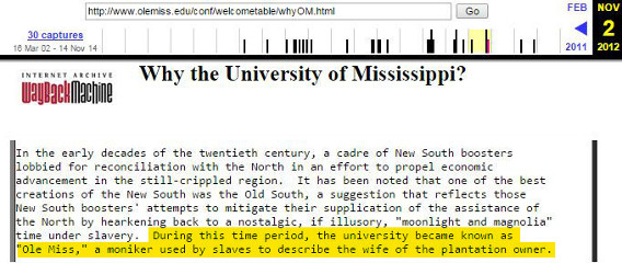
-
08-29-2021, 08:34 AM
#101

Originally Posted by
PCHSDawg

Gotta work tonight in Hattiesburg, best guess on what we're going to see?
You'll see sustained tropical force winds and possibly gusts to hurricane strength. Isolated tornadoes also possible.
-
08-29-2021, 09:00 AM
#102
Forecast for the Jackson metro area. Specifically Brandon area
-
08-29-2021, 09:03 AM
#103
Originally Posted by
starkvegasdawg
Latest recon data suggesting Ida is now a 5 with winds to 160. Have to see if they make that call officially.
Wow!!
-
08-29-2021, 09:10 AM
#104
Originally Posted by
starkvegasdawg
Looks like the Gulf may come alive early next week. There's currently a disturbance in the Caribbean that is forecast to become a closed low and gain tropical characteristics as it moves into the Gulf. Current forecast track and strengths are all over the place this far out but anywhere from New Orleans to Brownsville need to be keeping tabs on this as the potential...key word potential...is there for this to become a hurricane and possibly a major hurricane. The Gulf is currently a sauna with temps 85-90 degrees. We are now approaching the peak of the tropical Atlantic season so things getting active is to be expected.
Damn Vegas. Well done sir. Much better read than other stuff from those who get paid to write. Condensed perfectly for those who don't want 10 other paragraphs to siphon thru.
-
08-29-2021, 09:14 AM
#105
Originally Posted by
OLJWales
Damn Vegas. Well done sir. Much better read than other stuff from those who get paid to write. Condensed perfectly for those who don't want 10 other paragraphs to siphon thru.
I get most of my weather info here. When I'm offshore, I have a StormGeo subscription that I look at daily.
-
08-29-2021, 09:26 AM
#106
Originally Posted by
Dawgfan77
Forecast for the Jackson metro area. Specifically Brandon area
You'll see a slightly scaled down version of Hattiesburg. Winds will still be tropical storm force sustained but you may struggle to get a gust to hurricane force.
-
08-29-2021, 09:39 AM
#107
Originally Posted by
starkvegasdawg
Looks like the Gulf may come alive early next week. There's currently a disturbance in the Caribbean that is forecast to become a closed low and gain tropical characteristics as it moves into the Gulf. Current forecast track and strengths are all over the place this far out but anywhere from New Orleans to Brownsville need to be keeping tabs on this as the potential...key word potential...is there for this to become a hurricane and possibly a major hurricane. The Gulf is currently a sauna with temps 85-90 degrees. We are now approaching the peak of the tropical Atlantic season so things getting active is to be expected.
Originally Posted by
DownwardDawg
I get most of my weather info here. When I'm offshore, I have a StormGeo subscription that I look at daily.
So true. I love the way ED saves time when I want STATE info or weather. I"m in TX but my 80 yr old Mom still kickin it in Jacktown.
-
08-29-2021, 09:57 AM
#108
Originally Posted by
DownwardDawg
I get most of my extreme weather info here.
ETA: extreme
Me, too. When SVD speaks I listen. Thanks go to him and the other weather nerds on here. Y'all have my utmost respect.
-
08-29-2021, 10:03 AM
#109
Looks like it's done strengthening. 150mph 930. Now up to 933.
Should make landfall in next couple of hours
-
08-29-2021, 10:38 AM
#110
Hey StarkVegasDog check your Phone. Sent you some Pics. I gonna try to get down to HWY90 and get you some
-
08-29-2021, 10:42 AM
#111
Hey Timber looks like Low Tide is starting at my place. How is it at yours'?
-
08-29-2021, 10:46 AM
#112
Originally Posted by
parabrave
Hey StarkVegasDog check your Phone. Sent you some Pics. I gonna try to get down to HWY90 and get you some
Got them. I'll get them posted here shortly.
-
08-29-2021, 10:58 AM
#113
06EEB76C-1ED2-4925-8953-DC4AB4B01606.jpg 5302CDB0-92E8-4A13-92DA-125D72F2DBD4.jpg
Originally Posted by
starkvegasdawg
Got them. I'll get them posted here shortly.
-
08-29-2021, 11:01 AM
#114
Originally Posted by
starkvegasdawg
Pic 1 is Big Lake looking toward Industrial canal, Pic 2 is Gulfport Yacht Club
-
08-29-2021, 11:25 AM
#115
Originally Posted by
parabrave
Hey Timber looks like Low Tide is starting at my place. How is it at yours'?
We definitely have water coming up from the bayou but not too bad yet, I?m sure it?s going to get a good bit higher over the next several hours.
-
08-29-2021, 04:43 PM
#116
Tropical storm warnings have now been extended north to the 82 corridor. I had a feeling that was coming. Also hearing reports of gas stations as far north as new Albany running out of gas. Guess I need to go top off the old Ram with diesel. Going to be hard to chase the storm bands up here with no dead dinosaurs in the tank.
-
08-29-2021, 05:02 PM
#117
Storming good here in Biloxi Winds around 30 gusting to 50.
-
08-29-2021, 05:33 PM
#118
Utility trucks staging in Starkville. They got some long hard hours ahead of them.
-
08-29-2021, 05:57 PM
#119
Down in Baton Rouge, should get real here in a few hours
-
08-29-2021, 06:32 PM
#120
Originally Posted by
VandelayIndustries
Down in Baton Rouge, should get real here in a few hours
Well they might dodge the Nuclear bomb. Th storm might go east of them now, seems to be heading north up 55.
 Posting Permissions
- You may not post new threads
- You may not post replies
- You may not post attachments
- You may not edit your posts
-
Forum Rules
Disclaimer: Elitedawgs is a privately owned and operated forum that is managed by alumni of Mississippi State University. This website is in no way affiliated with the Mississippi State University, The Southeastern Conference (SEC) or the National Collegiate Athletic Association (NCAA). The views and opinions expressed herein are strictly those of the post author and may not reflect the views of other members of this forum or elitedawgs.com. The interactive nature of the elitedawgs.com forums makes it impossible for elitedawgs.com to assume responsibility for any of the content posted at this site. Ideas, thoughts, suggestion, comments, opinions, advice and observations made by participants at elitedawgs.com are not endorsed by elitedawgs.com
Elitedawgs: A Mississippi State Fan Forum, Mississippi State Football, Mississippi State Basketball, Mississippi State Baseball, Mississippi State Athletics. Mississippi State message board.


 Reply With Quote