-
OT: Hurricane Matthew Thread
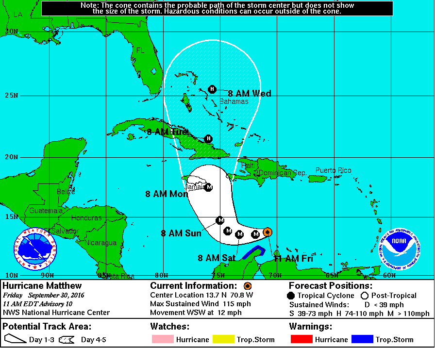
You may want to watch out for Hurricane Matthew that's spinning south of Hispanola. He is a Category 3 Hurricane right now, and is expected to strengthen further before making landfall in Jamaica. Matthew is getting the benefit of untouched waters to build and intensify. Current tracks have Matthew missing the Gulf of Mexico, due to a cutoff Low Pressure center over the middle of the country. Now the model guidance does not have landfall coming to Florida currently, but this could change within the next 3-4 days depending on the track Matthew takes through Jamaica and Cuba. Needless to say, the whole Eastern seaboard needs to be watching this system closely.
B.S. Geosciences, Professional Meteorology Concentration, Operational Emphasis
c/o 2015
Mississippi State University
@ColdSouthern911
Leicester City FC Owner
 Posting Permissions
- You may not post new threads
- You may not post replies
- You may not post attachments
- You may not edit your posts
-
Forum Rules
Disclaimer: Elitedawgs is a privately owned and operated forum that is managed by alumni of Mississippi State University. This website is in no way affiliated with the Mississippi State University, The Southeastern Conference (SEC) or the National Collegiate Athletic Association (NCAA). The views and opinions expressed herein are strictly those of the post author and may not reflect the views of other members of this forum or elitedawgs.com. The interactive nature of the elitedawgs.com forums makes it impossible for elitedawgs.com to assume responsibility for any of the content posted at this site. Ideas, thoughts, suggestion, comments, opinions, advice and observations made by participants at elitedawgs.com are not endorsed by elitedawgs.com
Elitedawgs: A Mississippi State Fan Forum, Mississippi State Football, Mississippi State Basketball, Mississippi State Baseball, Mississippi State Athletics. Mississippi State message board.


 Reply With Quote