

-

Originally Posted by
Commercecomet24

Yeah I saw it was confirmed by law enforcement. Said very large tornado. Dang!
It has since weakened but for a couple of scans it had a monster debris ball and debris was being lofted to 20,000'. That's a strong tornado. As a comparison, the Louisville EF-4 lofted debris 25,000'.
-
Watch issued
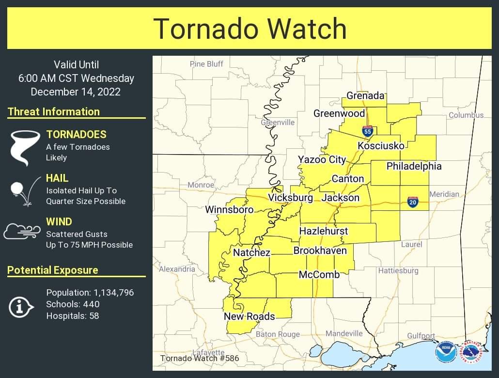
Last edited by starkvegasdawg; 12-14-2022 at 12:50 AM.
-
Originally Posted by
starkvegasdawg
Watch issued
SVD, it looks like the bad stuff may be creeping your way. Do you think conditions will hold up long enough to cause any concern for your area?
-
Originally Posted by
Dawg_Lover
SVD, it looks like the bad stuff may be creeping your way. Do you think conditions will hold up long enough to cause any concern for your area?
I honestly don't know. This storm has done way more than I thought it would ever do. I thought it would be confined much further south and even the current SPC outlook is saying that. I'm hoping those two rogue supercells that have been responsible for the tornado warnings are starting to be ingested into the main line. That will reduce the tornado threat so long as new ones don't develop. I need to be asleep but can't quit watching these storms. If they maintain intensity as they get closer then I'll ease into the truck and go take a look.
-
Originally Posted by
starkvegasdawg
It has since weakened but for a couple of scans it had a monster debris ball and debris was being lofted to 20,000'. That's a strong tornado. As a comparison, the Louisville EF-4 lofted debris 25,000'.
I hope no one was injured or homes lost.
-
Originally Posted by
starkvegasdawg
I honestly don't know. This storm has done way more than I thought it would ever do. I thought it would be confined much further south and even the current SPC outlook is saying that. I'm hoping those two rogue supercells that have been responsible for the tornado warnings are starting to be ingested into the main line. That will reduce the tornado threat so long as new ones don't develop. I need to be asleep but can't quit watching these storms. If they maintain intensity as they get closer then I'll ease into the truck and go take a look.
No driving into a 4th one okay?!
Be safe out there!
-
Time for the live streaming chasers on youtube.
-
Originally Posted by
starkvegasdawg
It has since weakened but for a couple of scans it had a monster debris ball and debris was being lofted to 20,000'. That's a strong tornado. As a comparison, the Louisville EF-4 lofted debris 25,000'.
Hey Vdog yall might want to stay up a few more hours.
-
Originally Posted by
parabrave
Hey Vdog yall might want to stay up a few more hours.
I'm trying. Storm doesn't look impressive on radar at the moment.
-
Looks like we're in the shooting gallery down here again!
-
Originally Posted by
Commercecomet24
Looks like we're in the shooting gallery down here again!
It's just starting for you. Take a look to the west. And now NWS just upgraded the pine belt to a moderate risk/
-
Originally Posted by
parabrave
It's just starting for you. Take a look to the west. And now NWS just upgraded the pine belt to a moderate risk/
Yeah they upgraded us about an hour ago. Not gonna be a fun day today!
-
Originally Posted by
Commercecomet24
Yeah they upgraded us about an hour ago. Not gonna be a fun day today!
Y?all stay safe down there. I have a niece living with her grandmother near Soso.
* Foghorn Leghorn-isms *
> about as subtle as a hand grenade in a barrel of oatmeal.
> more mixed up than a feather in a whirlwind.
> gettin so deep the farmers have to jack up the cows so they can milk em.
> making more noise than a couple of skeletons dancing on a tin roof.
-
Senior Member

Looks like a PDS is about to be issued for the southern half of the state. Many super cells ate ramping up.
-
Originally Posted by
Dawg_Lover
Y?all stay safe down there. I have a niece living with her grandmother near Soso.
Thanks! I live in Shady Grove so she's not to far away!
-
Senior Member
Amazing amount of hook echoes forming
-
Originally Posted by
Commercecomet24
Thanks! I live in Shady Grove so she's not too far away!
You really are then, because they are on 533 just north of Shady Grove-Moss Rd. You have more than your share of sketchy weather down there. Seems like every time I turn around, I am watching the radar in your part of the world. Hoping it winds down, for a while, after this.
-
Originally Posted by
Bodawg
Amazing amount of hook echoes forming
Yep the NWS New Orleans has 4 active warnings ongoing from Madisonville to Mccomb
-
Originally Posted by
Commercecomet24
Yeah they upgraded us about an hour ago. Not gonna be a fun day today!
Yep, and I'm at the clinic today in Oak Grove with my wife and kids at home alone.
-
Originally Posted by
Dawg_Lover
You really are then, because they are on 533 just north of Shady Grove-Moss Rd. You have more than your share of sketchy weather down there. Seems like every time I turn around, I am watching the radar in your part of the world. Hoping it winds down, for a while, after this.
Wow, she is close! Yeah it's always a shooting gallery down here. Hope they're safe. If there's every anything i can do for them, let me know!
 Posting Permissions
- You may not post new threads
- You may not post replies
- You may not post attachments
- You may not edit your posts
-
Forum Rules
Disclaimer: Elitedawgs is a privately owned and operated forum that is managed by alumni of Mississippi State University. This website is in no way affiliated with the Mississippi State University, The Southeastern Conference (SEC) or the National Collegiate Athletic Association (NCAA). The views and opinions expressed herein are strictly those of the post author and may not reflect the views of other members of this forum or elitedawgs.com. The interactive nature of the elitedawgs.com forums makes it impossible for elitedawgs.com to assume responsibility for any of the content posted at this site. Ideas, thoughts, suggestion, comments, opinions, advice and observations made by participants at elitedawgs.com are not endorsed by elitedawgs.com
Elitedawgs: A Mississippi State Fan Forum, Mississippi State Football, Mississippi State Basketball, Mississippi State Baseball, Mississippi State Athletics. Mississippi State message board.


 Reply With Quote


