

-
First spring severe threats on the horizon
The first one is Sunday. It it looks to be a very low end event and mainly confined to NW parts of the state. However, a potentially much more intense system looks to arrive Wednesday. While still several days away this one looks to have the potential to be interesting with all modes of severe weather possible. Jackson NWS is already mentioning it in their graphics and discussions as is Memphis and Birmingham. As of right now Birmingham is using the most ominous language as they're painting some pretty textbook severe parameters to be in place. Still a lot of uncertainty to be ironed out and exact strength and timing still to be determined, but if you have any St Paddy's day plans then be weather aware. As for me, this looks like it may be my first chase day on my birthday. And I'm half Irish. Got to be a good omen, right?
-
Geez, sure hoping you do not end up chasing in the Desoto County area.
Yikes 😳
-
Headed for gatlinburg tomorrow from the Florida panhandle. Staying in bham tomorrow night then on to gatlinburg Sunday. Supposed to be coming home Wednesday.
Thoughts?
-

Originally Posted by
STATEBALLIN

Headed for gatlinburg tomorrow from the Florida panhandle. Staying in bham tomorrow night then on to gatlinburg Sunday. Supposed to be coming home Wednesday.
Thoughts?
Could be a rough drive home. Timing is still to be determined but early returns are focusing on eastern MS into AL Wednesday afternoon into evening. Just connect the dots from Jackson to Hattiesburg to Birmingham to Montgomery to get a rough idea of the main target area as things look now. Then to be safe I'd expand that border another 50 miles each direction. Now, that area will change between now and then as we get closer to the event and more info becomes available.
-
Originally Posted by
starkvegasdawg
Could be a rough drive home. Timing is still to be determined but early returns are focusing on eastern MS into AL Wednesday afternoon into evening. Just connect the dots from Jackson to Hattiesburg to Birmingham to Montgomery to get a rough idea of the main target area as things look now. Then to be safe I'd expand that border another 50 miles each direction. Now, that area will change between now and then as we get closer to the event and more info becomes available.
Right on. I must add that I will be pulling a camper also. I?ll look into extending our stay one more night or come home a day early. Hmm...Will continue to monitor. Thanks!
-
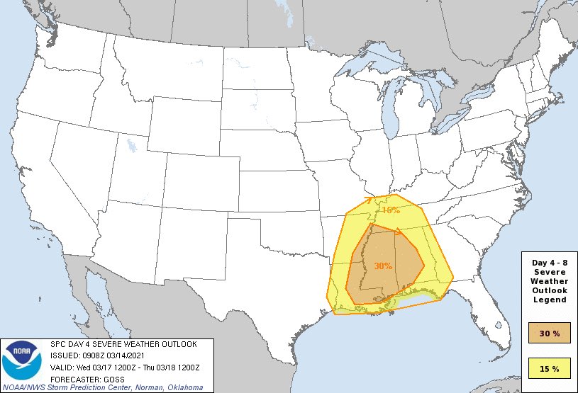
Here's the latest info. Area has expanded. You're typically looking for values of 65+ for significant tornadoes.

-
Originally Posted by
starkvegasdawg
Here's the latest info. Area has expanded. You're typically looking for values of 65+ for significant tornadoes.
Edit. I see it now. It wasn't showing on my phone earlier.
Last edited by DownwardDawg; 03-13-2021 at 07:11 PM.
-
Flying in from offshore to Houma early Wednesday morning then driving home to Hwy 84 Covington county. What are my chances of getting in?
-
Originally Posted by
starkvegasdawg
Could be a rough drive home. Timing is still to be determined but early returns are focusing on eastern MS into AL Wednesday afternoon into evening. Just connect the dots from Jackson to Hattiesburg to Birmingham to Montgomery to get a rough idea of the main target area as things look now. Then to be safe I'd expand that border another 50 miles each direction. Now, that area will change between now and then as we get closer to the event and more info becomes available.
Dang starkvegasdawg, you bringing the heat as I am heading to Gatlinburg Wednesday for several days! Stop this madness*
-
We?re driving home from Fort Worth to the MS Coast Tuesday afternoon through late night. Do you think we would end up driving through this? We were planning to hit Shreveport probably late afternoon and then South through Alexandria and Baton Rouge.
-
if you really want storm action head to texas-oklahoma and kansas..they are forcasting long tracking tornados next 2 days.
-
While there's still some timing and other differences among the models, I am not seeing anything that dissuades me from believing Wednesday could see a significant severe weather event for MS and AL. I still can't mail down where the worst will set up this far out, so those of you asking about specific locations - I just don't know yet. By tomorrow the storm will be in range of the NAM. It is trying to show significant severe storms approaching the MS River by 7:00am that morning. Some of the other models are holding off until around noon for the storms to get into MS. All of these finer details will work themselves out over the next 24-36 hours, but this could well be a case of storms developing early in the day and not waiting for max heating in the afternoon. The early forecast soundings are showing a very favorable environment for storms to develop and sustain rotating updrafts. This will be conducive for all modes of severe weather including tornadoes...a couple of which could be violent and long tracked.
-
The SPC has now updated all of MS to an enhanced risk for severe thunderstorms for Wednesday. The ingredients may be starting to come together for a tornado outbreak. They did mention that there is still some location issues with the GFS concentrating the threat into southern TN and the euro placing the threat more into central MS and AL. They have come into better agreement on timing with Wednesday afternoon now looking like when things get serious. Details will continue to be fine tuned, but things are really starting to look serious.
-
What about the baseball game on Tuesday? Any chance rain affects it? I'm driving up for my first game since Texas Tech last year which was the last games we played.
-
-
Originally Posted by
msudawg1200
What about the baseball game on Tuesday? Any chance rain affects it? I'm driving up for my first game since Texas Tech last year which was the last games we played.
Game on Tuesday should be ok.
-
Overall threat is still enhanced but has now had a hatched area added for more of north and central MS for higher chances of significant severe weather Wednesday. Nothing has happened to lower the threat for this system. Winds to 70mph, hail to golf ball and probably bigger, and several tornadoes - some possibly long tracked and violent - still look like a good bet. Timing looks to be late morning through the evening. As of right now the worst tornado threat looks to reside along and just south of the warm front as it lifts northward tomorrow.

-
-
Originally Posted by
starkvegasdawg
Overall threat is still enhanced but has now had a hatched area added for more of north and central MS for higher chances of significant severe weather Wednesday. Nothing has happened to lower the threat for this system. Winds to 70mph, hail to golf ball and probably bigger, and several tornadoes - some possibly long tracked and violent - still look like a good bet. Timing looks to be late morning through the evening. As of right now the worst tornado threat looks to reside along and just south of the warm front as it lifts northward tomorrow.
Keep us posted brother. This is where I look first.
Still got my fingers crossed for my helicopter flight wednesday morning then my drive up I-55 and across 84 to home.
-
Originally Posted by
Churchill
You going to chase ?

 Posting Permissions
- You may not post new threads
- You may not post replies
- You may not post attachments
- You may not edit your posts
-
Forum Rules
Disclaimer: Elitedawgs is a privately owned and operated forum that is managed by alumni of Mississippi State University. This website is in no way affiliated with the Mississippi State University, The Southeastern Conference (SEC) or the National Collegiate Athletic Association (NCAA). The views and opinions expressed herein are strictly those of the post author and may not reflect the views of other members of this forum or elitedawgs.com. The interactive nature of the elitedawgs.com forums makes it impossible for elitedawgs.com to assume responsibility for any of the content posted at this site. Ideas, thoughts, suggestion, comments, opinions, advice and observations made by participants at elitedawgs.com are not endorsed by elitedawgs.com
Elitedawgs: A Mississippi State Fan Forum, Mississippi State Football, Mississippi State Basketball, Mississippi State Baseball, Mississippi State Athletics. Mississippi State message board.


 Reply With Quote


