-
Member


Originally Posted by
ScoobaDawg

OK rch. I'm changing after reviewing some things this morning.
I would contact your guy and ask deadlines. Models are more west this morning.. But if it gets stronger that makes it turn more north faster than drifting west. Lots to watch but it's barely went across the land today looks like.. So that means it's in better shape earlier which likely means stronger...
Condo owner is a great guy. He let us move the date at no extra fee. This is after we already moved it in May due to coronavirus. We will try it again later and hope for better weather.... think we may hit Pigeon Forge area for a few days next week instead. Thanks for the info SVD and Scooba !
-
Where is our update? You guys are more accurate than these tv goons
-
Originally Posted by
Uncle Ruckus
Where is our update? You guys are more accurate than these tv goons
don't be anywhere between Gulfport and Grand Isle. The models keep shifting every hour but the NHC is starting to go with the GFS which has it going up between Grand Island and SW pass then up to NO.
-
You mean Hancock County, where I live?
-
Originally Posted by
Uncle Ruckus
Where is our update? You guys are more accurate than these tv goons
We do sleep also.. and then need some time to analyze the updates.. and not just from one source.
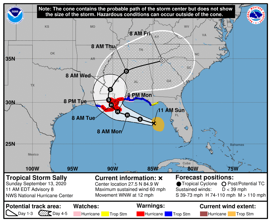
To start with..the most important parts. If you are on the coast of east LA or the MS/ Bama gulf coast... Take note. this storm might not spin up to a higher hurricane category in the end, but there will be big time surge, and with the angle of the landfall (moving NW) and the coastline, it will intensify the storm surge amount. Add to that the likely Hurricane will CONTINUE to strengthen as making landfall at an EXTREMELY slow speed... adds up to not good things and MUST be watched. Massive Surge, Flash Flooding, and tornadoes possibly.
Now some notes...
7am update had TS Sally at 50mph. New 10am update has winds now up to 60mph. There is shear out of the NW that has been keeping the storm from developing while off the coast of FL but that shear is degrading fast.
Landfall is thought to occur around 8pm Monday with the middle of the cone currently being around the area of the mouth of the MS.
Hurricane warnings have just been issued for the ms gulf coast and part of LA.

Last edited by ScoobaDawg; 09-13-2020 at 11:27 AM.
-
Originally Posted by
Uncle Ruckus
You mean Hancock County, where I live?
Yep.
-
Member
-
Starting to see some grumblings that Sally May be making an eastward shift in track putting MS back in the crosshairs for a landfall location. This afternoon I had all but written off chasing, but if that happens then I'll be making a record setting storm chase prep and booking it south tomorrow.
-
Local Baton Rouge news reported its slightly changed track to more east. MS seems to be under the gun even the east side
-
We now officially have a track change by the nhc. Landfall looks to be around 7:00pm Tuesday evening around Bay St Louis...assuming it doesn't change again. If this holds tomorrow then I'm heading south.
-
Originally Posted by
starkvegasdawg
We now officially have a track change by the nhc. Landfall looks to be around 7:00pm Tuesday evening around Bay St Louis...assuming it doesn't change again. If this holds tomorrow then I'm heading south.
Damn. Hancock Co hang in there
-
NHC saying track may have to be adjusted further east overnight. Lot of factors coming into play to determine where she ends up. However, biggest thing of concern is the thinking forward speeds slow down. This may end up being a prolific rainmaker for somebody.
-
10pm update. shear is dissipating and convection is exploding, and eye wall has formed but is still open to the SW per last recon plane pass.

-
Originally Posted by
ScoobaDawg
10pm update. shear is dissipating and convection is exploding, and eye wall has formed but is still open to the SW per last recon plane pass.
What are the chances it becomes larger than a cat 2? Is it even still projected to reach cat 2?
-
Originally Posted by
TimberBeast
What are the chances it becomes larger than a cat 2? Is it even still projected to reach cat 2?
Cat 2 very possible. Cat 3 Not very likely. Even if it undergoes RI tomorrow, that would be 35 mph over 24 hours which puts you up to 95 (9 is cat 2). It would need another 15mph to get to cat3.
The path has slowed down so it's possible but it would really need to get things in order overnight.. which it has started.
-
Originally Posted by
ScoobaDawg
Cat 2 very possible. Cat 3 Not very likely. Even if it undergoes RI tomorrow, that would be 35 mph over 24 hours which puts you up to 95 (9 is cat 2). It would need another 15mph to get to cat3.
The path has slowed down so it's possible but it would really need to get things in order overnight.. which it has started.
What?s your opinion on the track? Shifting more eastward towards the MS Coast or more towards NOLA? We?re trying to figure out whether or not to stay put tomorrow on the east MS coast. I know it?s not exact but I trust yalls input more than most.
-
Originally Posted by
TimberBeast
What?s your opinion on the track? Shifting more eastward towards the MS Coast or more towards NOLA? We?re trying to figure out whether or not to stay put tomorrow on the east MS coast. I know it?s not exact but I trust yalls input more than most.
Lot of variables in play now. But nhc is thinking a shift further east is possible. Hopefully, know more when we wake up in the morning.
-
Member
-
Originally Posted by
Littleman
Yeah thanks for that, any updates would be great
-
Originally Posted by
BeastMan
Damn. Hancock Co hang in there
Going to be interesting to see what happens with this storm and hancock county. Lots of low lying areas, but those low lying areas were mostly wiped out by Katrina, and anybody that didn't rebuild before they redid the firm maps should be fine. Should be mostly stuff inland and upriver that gets flood damage. Those are the structures that survived Katrina enough that people got in and repaired them before the new FIRM maps.
 Posting Permissions
- You may not post new threads
- You may not post replies
- You may not post attachments
- You may not edit your posts
-
Forum Rules
Disclaimer: Elitedawgs is a privately owned and operated forum that is managed by alumni of Mississippi State University. This website is in no way affiliated with the Mississippi State University, The Southeastern Conference (SEC) or the National Collegiate Athletic Association (NCAA). The views and opinions expressed herein are strictly those of the post author and may not reflect the views of other members of this forum or elitedawgs.com. The interactive nature of the elitedawgs.com forums makes it impossible for elitedawgs.com to assume responsibility for any of the content posted at this site. Ideas, thoughts, suggestion, comments, opinions, advice and observations made by participants at elitedawgs.com are not endorsed by elitedawgs.com
Elitedawgs: A Mississippi State Fan Forum, Mississippi State Football, Mississippi State Basketball, Mississippi State Baseball, Mississippi State Athletics. Mississippi State message board.


 Reply With Quote