

-
Latest from Jackson NWS. It's getting real.
Attention quickly turns to a more robust, and potentially
significant, severe weather episode Saturday into Sunday. Intense
Pacific jet energy diving through the Great Basin will help carve
out a potent shortwave trough that will eject out of the Desert
Southwest and into the Southern Plains before propagating into the
Lower Mississippi River Valley over the weekend. The stalled frontal
boundary will lift back north as a warm front with a marine layer
airmass characteristic of upper 60s to low 70s dewpoints advecting
well inland to the Hwy 82 corridor. While convective evolution will
be governed by mesoscale details that cannot be resolved at this
time range, the parameter space and synoptic evolution will be
supportive of several rounds of storms with all modes of severe
weather expected. Backed low-level flow will help elongate long
looping cyclonically curved hodographs within a moderately unstable
airmass with the potential for supercell activity within bands of
prefrontal confluent flow. Will maintain the enhanced risk across
portions of the area in the HWO/graphics and further upgrades could
be warranted with the potential for a severe weather outbreak not
out of the question.
-

Originally Posted by
starkvegasdawg

Latest from Jackson NWS. It's getting real.
Attention quickly turns to a more robust, and potentially
significant, severe weather episode Saturday into Sunday. Intense
Pacific jet energy diving through the Great Basin will help carve
out a potent shortwave trough that will eject out of the Desert
Southwest and into the Southern Plains before propagating into the
Lower Mississippi River Valley over the weekend. The stalled frontal
boundary will lift back north as a warm front with a marine layer
airmass characteristic of upper 60s to low 70s dewpoints advecting
well inland to the Hwy 82 corridor. While convective evolution will
be governed by mesoscale details that cannot be resolved at this
time range, the parameter space and synoptic evolution will be
supportive of several rounds of storms with all modes of severe
weather expected. Backed low-level flow will help elongate long
looping cyclonically curved hodographs within a moderately unstable
airmass with the potential for supercell activity within bands of
prefrontal confluent flow. Will maintain the enhanced risk across
portions of the area in the HWO/graphics and further upgrades could
be warranted with the potential for a severe weather outbreak not
out of the question.
I like to see the cliff notes please**
-
Originally Posted by
basedog
I like to see the cliff notes please**
Instability and windshear are all setting up to set the stage for a possible of outbreak of tornado producing supercells Saturday.
-
Originally Posted by
starkvegasdawg
Instability and windshear are all setting up to set the stage for a possible of outbreak of tornado producing supercells Saturday.
Thanks, I think I will pass on the games Saturday!
-
Originally Posted by
basedog
Thanks, I think I will pass on the games Saturday!
Latest models are showing the weather to come through between the evening to early sunday am. Very subject to change between now and Saturday. but trending towards a better outcome.
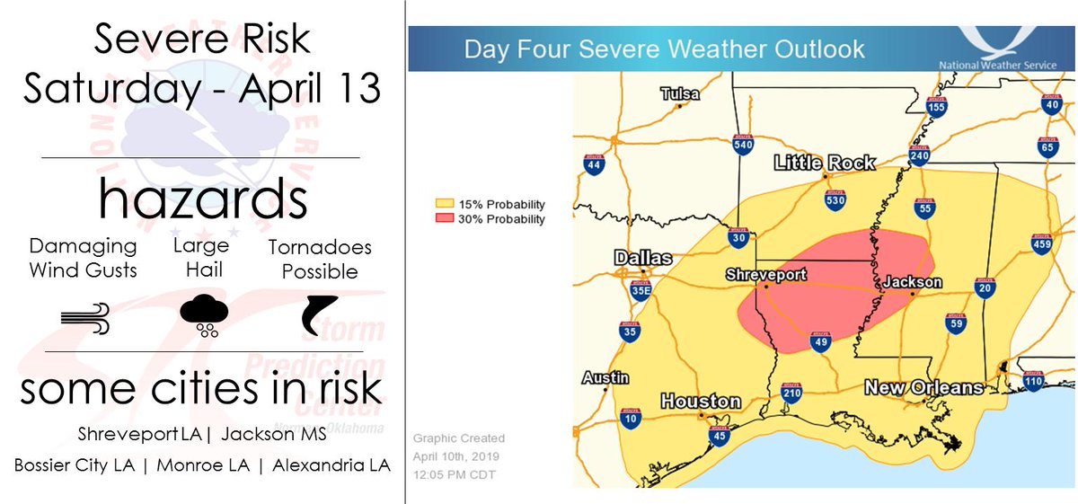
Also the greater risk is Jackson to Winona and back to the state line to the SW.
Last edited by ScoobaDawg; 04-10-2019 at 05:03 PM.
-
Originally Posted by
basedog
Thanks, I think I will pass on the games Saturday!
Timing for Starkville Saturday may be close to dark.
-
Originally Posted by
ScoobaDawg
Latest models are showing the weather to come through between the evening to early sunday am. Very subject to change between now and Saturday. but trending towards a better outcome.
Also the greater risk is Jackson to Winona and back to the state line to the SW.
Better outcome meaning it’s getting here later or better outcome meaning it’s not gonna be as bad around the golden triangle?
-
Originally Posted by
shoeless joe
Better outcome meaning it’s getting here later or better outcome meaning it’s not gonna be as bad around the golden triangle?
Better outcome for the games. Intensity can't be pegged to a great extent yet.
-
Things starting to not look so bleak for Starkville. Looks like most festivities should stay dry until after dark and the severe threat for here not looking as bad with current model runs. Same can't be said for LA, though. Still looking like a very rough day, there.
-
Thurs morning update. Looks like there might be some rain in the area during Tomorrow nights game but hopefully holds off until the game is done.
Should be a beautiful day Saturday for the football and baseball games. Maybe a few pop up showers but should be clear through the early evening. From 7pm to 7am is the time frame we have to watch for now. Depending on the speed of the front. Sunday should be a beautiful day in the upper 60s.
-
Originally Posted by
ScoobaDawg
Thurs morning update. Looks like there might be some rain in the area during Tomorrow nights game but hopefully holds off until the game is done.
Should be a beautiful day Saturday for the football and baseball games. Maybe a few pop up showers but should be clear through the early evening. From 7pm to 7am is the time frame we have to watch for now. Depending on the speed of the front. Sunday should be a beautiful day in the upper 60s.
What about Saturday morning at daylight
-
Originally Posted by
BuckyIsAB****
What about Saturday morning at daylight
I'd say anytime in Starkville before 6:00pm should be just fine. NWS has expanded their enhanced risk back east again but not to Starkville.
-
Originally Posted by
starkvegasdawg
I'd say anytime in Starkville before 6:00pm should be just fine. NWS has expanded their enhanced risk back east again but not to Starkville.
So in your opinion is this storm bad enough to run people off who were planning on making the trip
-
-
Originally Posted by
BuckyIsAB****
So in your opinion is this storm bad enough to run people off who were planning on making the trip
I wouldn't let it deter me. I'm still thinking this will peak over in LA. Maybe western MS.
-
Originally Posted by
starkvegasdawg
I wouldn't let it deter me. I'm still thinking this will peak over in LA. Maybe western MS.
Man are yall sure about this my weather forecast still says rain all day haha like at least 50-60 percent then get worse at night
-
SPC has now upgraded Satruday to a moderate risk. Discussion has this shaping up to be a dangerous day in the red and orange shaded areas. Starkville is still in the slight risk and I still expect any organized storms to hold off until dark. Storm mode by then should, key word should, be mainly linear which will reduce the tornado threat. But if you have interests in the red shaded area storm mode should be discrete and strong tornadoes will be possible.

-
-
Originally Posted by
starkvegasdawg
What do you think about the orange area? I know what the language says on the graph, but interested in your thoughts on how serious
-
They may wanna consider moving the ballgame start time up to 1 pm or 2 pm. I know that'll conflict with the spring game but a 3 pm start would mean at least a 6 pm finish or later. Means a bunch of folks on the road driving home by the time it moves through.
 Posting Permissions
- You may not post new threads
- You may not post replies
- You may not post attachments
- You may not edit your posts
-
Forum Rules
Disclaimer: Elitedawgs is a privately owned and operated forum that is managed by alumni of Mississippi State University. This website is in no way affiliated with the Mississippi State University, The Southeastern Conference (SEC) or the National Collegiate Athletic Association (NCAA). The views and opinions expressed herein are strictly those of the post author and may not reflect the views of other members of this forum or elitedawgs.com. The interactive nature of the elitedawgs.com forums makes it impossible for elitedawgs.com to assume responsibility for any of the content posted at this site. Ideas, thoughts, suggestion, comments, opinions, advice and observations made by participants at elitedawgs.com are not endorsed by elitedawgs.com
Elitedawgs: A Mississippi State Fan Forum, Mississippi State Football, Mississippi State Basketball, Mississippi State Baseball, Mississippi State Athletics. Mississippi State message board.


 Reply With Quote


