

-

Originally Posted by
Westdawg

I am in Clarksdale and headed to northwest TN today. Leaving between 10:30 and noon.
Am I about to ride straight into this bad stuff?
Yep.
-
Senior Member


Originally Posted by
MetEdDawg
Accurate post here. Moderate is not a term to use lightly. If you live in about a 150 mile radius of Memphis, you need to be extremely focused on this event as you could see some very very dangerous weather.
Now that's not to say everyone else shouldn't be focused, but that's the high focus area. Everyone still needs to be on high alert though. This is setting up to be a bad one.
Wonderbau.
-
Senior Member

Thanks for the info everyone. Staying on the MS gulf coast with my wife's family for Christmas. What's the outlook here?
-
Originally Posted by
SignalToNoise
Thanks for the info everyone. Staying on the MS gulf coast with my wife's family for Christmas. What's the outlook here?
You're probably in the safest place you could be and still be in MS.
-
Just noticed the weather channel took the TornCon up to 8 in North MS. How far south does that extend ? What's the outlook for Starkville?
-
Awe crap. Here comes the sun in Webster county. Seems I read you said look out if the sun comes out.
Originally Posted by
starkvegasdawg
You're probably in the safest place you could be and still be in MS.
-
Originally Posted by
DLGDawg
Awe crap. Here comes the sun in Webster county. Seems I read you said look out if the sun comes out.
Yep. That's fuel on the fire.
-
Sun poking out in Holmes county as well
my cowbell is louder than yours
-
Originally Posted by
THE Bruce Dickinson
Just noticed the weather channel took the TornCon up to 8 in North MS. How far south does that extend ? What's the outlook for Starkville?
Down to hwy 82 corridor. Probably not far enough east to hit Starkville but close.
-
Yeah. Sunlight before an event is just fuel. Cloudy skies here in Greenville, but the temperatures are hovering around 70 ?F
B.S. Geosciences, Professional Meteorology Concentration, Operational Emphasis
c/o 2015
Mississippi State University
@ColdSouthern911
Leicester City FC Owner
-
The Storm Prediction Center has issued a Mesoscale Discussion for the North half of the state. Tornado watch is about to be issued for the area. How confident are they? 95% chance of watch issuance soon.
Mesoscale Discussion: http://www.spc.noaa.gov/products/md/md2036.html

B.S. Geosciences, Professional Meteorology Concentration, Operational Emphasis
c/o 2015
Mississippi State University
@ColdSouthern911
Leicester City FC Owner
-
Weather Channel mentioning the sun and instability across central and east MS into Bama as well. Said it could be a rough afternoon and night from Jackson north and east
-
Heading from Columbus towards smith cnty around 2 pm. Would going 45 to meridian be any safer than taking 25 to Carthage, since it's further east?
And thanks guys for keeping us up on all the latest. Much better info hear versus anywhere else...it is much appreciated.
-
Originally Posted by
shoeless joe
Heading from Columbus towards smith cnty around 2 pm. Would going 45 to meridian be any safer than taking 25 to Carthage, since it's further east?
And thanks guys for keeping us up on all the latest. Much better info hear versus anywhere else...it is much appreciated.
It may delay it if you take 45 down to Meridian. Plus it's a little more wide open so you might be able to get out of the way/into a ditch sooner.
B.S. Geosciences, Professional Meteorology Concentration, Operational Emphasis
c/o 2015
Mississippi State University
@ColdSouthern911
Leicester City FC Owner
-
Originally Posted by
shoeless joe
Heading from Columbus towards smith cnty around 2 pm. Would going 45 to meridian be any safer than taking 25 to Carthage, since it's further east?
And thanks guys for keeping us up on all the latest. Much better info hear versus anywhere else...it is much appreciated.
That early either route may not matter but 45 would have the least chance of storms.
-
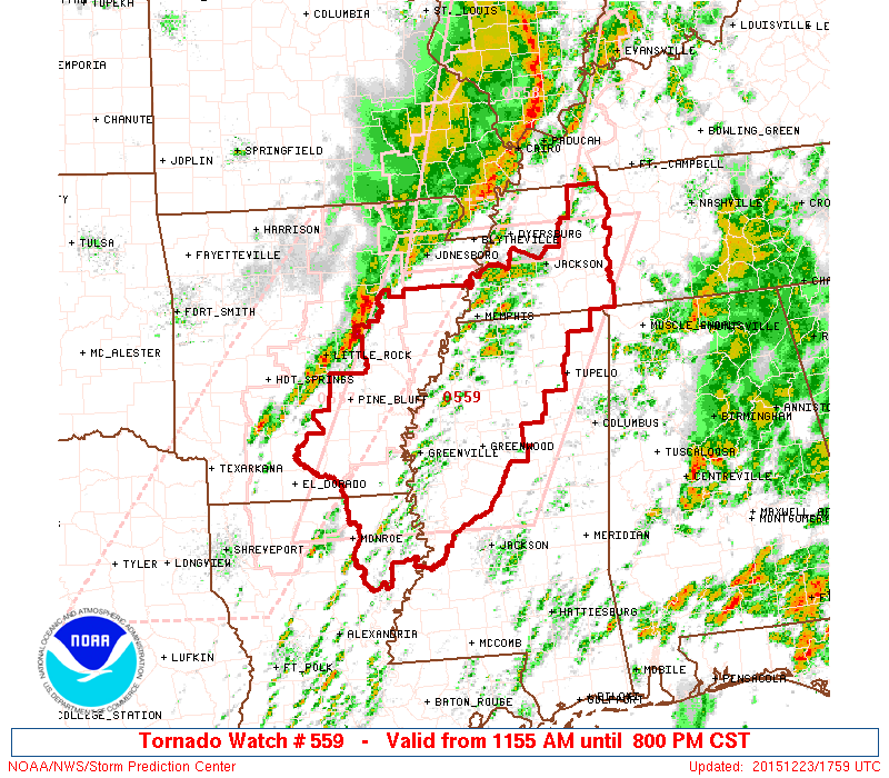
Tornado Watch #559 has been issued for NW Mississippi. This is a PDS watch, which means a Potentially Dangerous Situation. This is the highest classification for a Tornado Watch, which means the tornado threat is VERY real today.
B.S. Geosciences, Professional Meteorology Concentration, Operational Emphasis
c/o 2015
Mississippi State University
@ColdSouthern911
Leicester City FC Owner
-
good job guys and thanks for the updates ...... love having our own ED weather channel
OXFORD, Miss. (WTVA) - Ole Miss campus police ask students to behave at future baseball games following a recent incident.
The university said students were reportedly throwing rocks at Georgia baseball players during last weekend's series.
-
Senior Member
Cell around Cleveland already showing rotation.
-
Just a reminder, just because you see sunlight today doesn't mean you're in the clear. Sunlight=Heat=Fuel
B.S. Geosciences, Professional Meteorology Concentration, Operational Emphasis
c/o 2015
Mississippi State University
@ColdSouthern911
Leicester City FC Owner
-
 Posting Permissions
- You may not post new threads
- You may not post replies
- You may not post attachments
- You may not edit your posts
-
Forum Rules
Disclaimer: Elitedawgs is a privately owned and operated forum that is managed by alumni of Mississippi State University. This website is in no way affiliated with the Mississippi State University, The Southeastern Conference (SEC) or the National Collegiate Athletic Association (NCAA). The views and opinions expressed herein are strictly those of the post author and may not reflect the views of other members of this forum or elitedawgs.com. The interactive nature of the elitedawgs.com forums makes it impossible for elitedawgs.com to assume responsibility for any of the content posted at this site. Ideas, thoughts, suggestion, comments, opinions, advice and observations made by participants at elitedawgs.com are not endorsed by elitedawgs.com
Elitedawgs: A Mississippi State Fan Forum, Mississippi State Football, Mississippi State Basketball, Mississippi State Baseball, Mississippi State Athletics. Mississippi State message board.


 Reply With Quote


