
-
Next possible severe threats
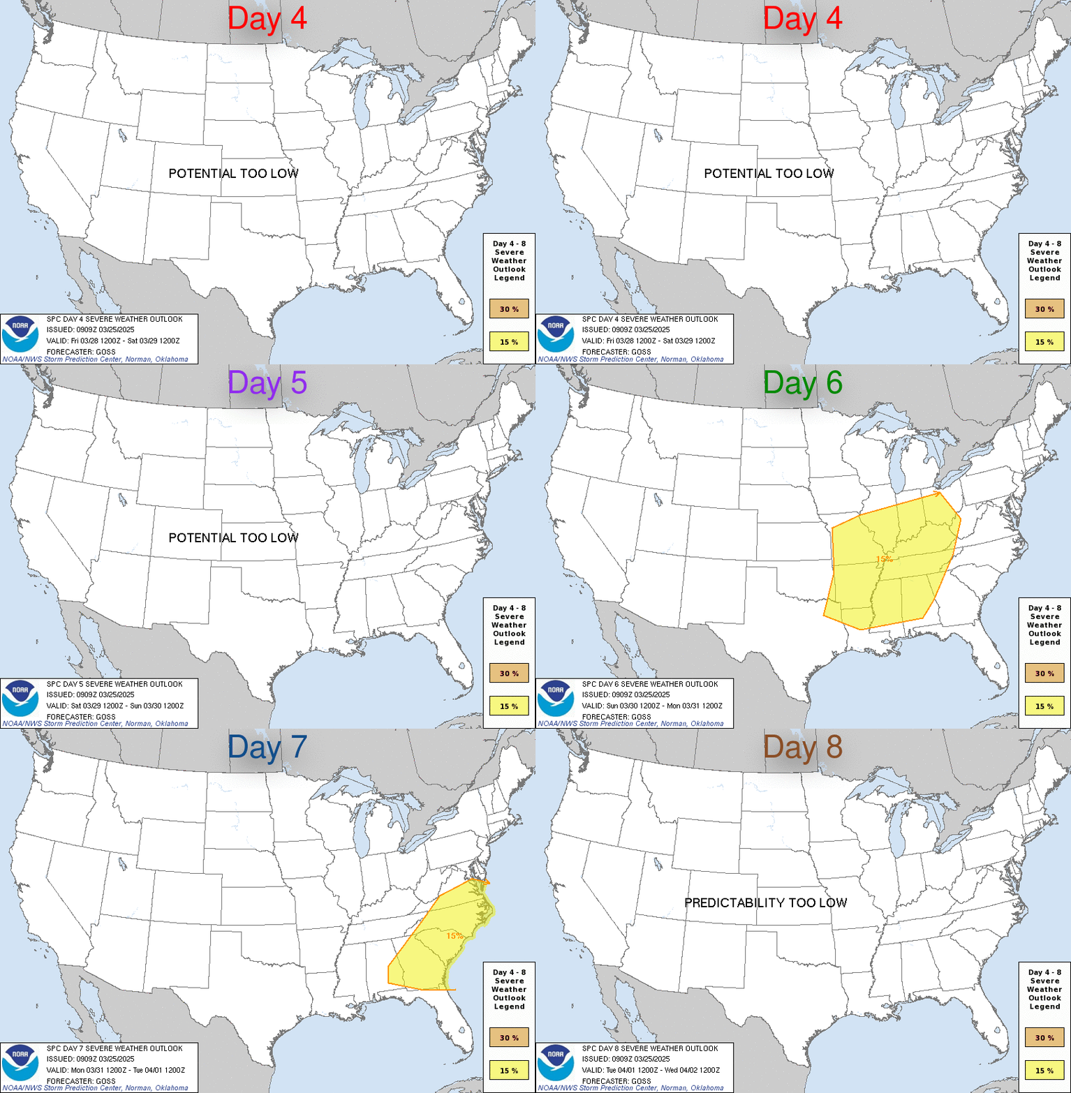
I may be jumping the gun a little on this, but I'm doing it anyway. The next severe threat looks to be this Sunday. It will be primarily for areas of MS along and south of I-20. Right now main threats look to be damaging straight line winds and hail. The tornado threat for Sunday's system doesn't look to impressive currently. However, a second more potent threat looks to be looming on the horizon for next Wednesday. I hesitated to even mention this one eight days out, but with so many people still in clean up mode after Sunday I wanted to give as much heads up as possible to what might be coming down the pipeline. Just keep in mind this far out a lot can and will change. It's even possible the models will kill the system, but the GFS has been pretty consistent with it for a while. Not going to go into details about what is and is not expected with this possible event, but I will mention that as of right now all modes of severe weather look possible. Now I'll let Ref chastise me for mentioning something this far out.
-
Stark ... you shouldn't take chastisement from anyone because you're too good at what you do ... I (and most of the board) have learned to take your reports as gospel .... and I live in Atlanta where we almost always get what you're predicting in Mississippi and even my extended family East of Nashville seems to get very similar weather
thanks and never hesitate to share what you see - no matter how far out
OXFORD, Miss. (WTVA) - Ole Miss campus police ask students to behave at future baseball games following a recent incident.
The university said students were reportedly throwing rocks at Georgia baseball players during last weekend's series.
-

Originally Posted by
FISHDAWG

Stark ... you shouldn't take chastisement from anyone because you're too good at what you do ... I (and most of the board) have learned to take your reports as gospel .... and I live in Atlanta where we almost always get what you're predicting in Mississippi and even my extended family East of Nashville seems to get very similar weather
thanks and never hesitate to share what you see - no matter how far out
I agree 100%
-
Keep bringing the info my man! Greatly appreciated!
-

Originally Posted by
FISHDAWG

Stark ... you shouldn't take chastisement from anyone because you're too good at what you do ... I (and most of the board) have learned to take your reports as gospel .... and I live in Atlanta where we almost always get what you're predicting in Mississippi and even my extended family East of Nashville seems to get very similar weather
thanks and never hesitate to share what you see - no matter how far out
The reason you don't mention possible severe or snow events this far out is that they can, and usually do, change dramatically or fizzle out completely, and by mentioning it early it causes unease in people too early...especially when reason number one happens and it fizzles out.
-

Originally Posted by
starkvegasdawg

The reason you don't mention possible severe or snow events this far out is that they can, and usually do, change dramatically or fizzle out completely, and by mentioning it early it causes unease in people too early...especially when reason number one happens and it fizzles out.
there's something to "just being aware of the possibility" whether it pans out or not - keep it coming
ETA - you get a pass on being wrong here ... and you're probably the only poster that has that privilege
OXFORD, Miss. (WTVA) - Ole Miss campus police ask students to behave at future baseball games following a recent incident.
The university said students were reportedly throwing rocks at Georgia baseball players during last weekend's series.
-
I never pass up on your threads.
Praise The Lord and Go Dawgs!!!
-
I will say this. The CIPS analogs are picking up on these two potential events now. A CIPS analog sees what the forecast environment looks like and finds past severe weather events with similar setups as sort of an educated guess of what can be expected from this set up. The latest analogs are running pretty close to what I put in my original post. Not to gloss over Sunday, but my attention is pretty focused on next Wednesday.
-
I like the way you did this post...basically "Hey y'all, be aware there could be some severe weather on these days but it's a long ways out and could change." That gets me looking as those times get closer.
-
You can't get better weather info than what we get on here from SVD, Ref, and others who post info on here. It's invaluable!
-

Originally Posted by
Commercecomet24

You can't get better weather info than what we get on here from SVD, Ref, and others who post info on here. It's invaluable!
They pretty good. I check in to see what they say.
-

Originally Posted by
Commercecomet24

You can't get better weather info than what we get on here from SVD, Ref, and others who post info on here. It's invaluable!
Late Saturday night, my girlfriend was asking when it was going to start getting bad. This site was the first place I checked. My hat is off to all the weather guys on here!
All Aboard and Soft Landings!
-
The threat for Sunday is now starting to take shape. Below is the area outlined by the SPC with a day 4 enhanced area. Damaging winds and hail look to be the main threat, but disturbingly, there are some possibilities a tornado threat may emerge after dark Sunday. Just have to see how it all plays out.

Last edited by starkvegasdawg; 04-16-2020 at 04:13 AM.
-
time to make a run on toilet paper
OXFORD, Miss. (WTVA) - Ole Miss campus police ask students to behave at future baseball games following a recent incident.
The university said students were reportedly throwing rocks at Georgia baseball players during last weekend's series.
-

Originally Posted by
iPat09

Late Saturday night, my girlfriend was asking when it was going to start getting bad. This site was the first place I checked. My hat is off to all the weather guys on here!
Yep, we have some good ones!
-

Here is the latest graphic on the Sunday severe threat. Reading the forecast discussion from Jackson NWS they were mentioning models starting to show an increase in low level shear. If that happens, then the tornado threat will also increase. The NAM is already picking up on this and showing some high STP (significant tornado parameter) values for Sunday afternoon and night, but it is centering the highest values into south AL and the FL panhandle at this time. There is also still some uncertainty over storm mode. Last I saw the main mode was looking to be what we call in meteorological circles a big mess. Will have to see if these shear values changing make the environment more favorable for discrete cells.
Right now not looking for anything to the degree of what we saw this past Sunday. That one tornado has now been confirmed at least 2.25 miles wide making it the third largest on record.
-

Originally Posted by
starkvegasdawg


Here is the latest graphic on the Sunday severe threat. Reading the forecast discussion from Jackson NWS they were mentioning models starting to show an increase in low level shear. If that happens, then the tornado threat will also increase. The NAM is already picking up on this and showing some high STP (significant tornado parameter) values for Sunday afternoon and night, but it is centering the highest values into south AL and the FL panhandle at this time. There is also still some uncertainty over storm mode. Last I saw the main mode was looking to be what we call in meteorological circles a big mess. Will have to see if these shear values changing make the environment more favorable for discrete cells.
Right now not looking for anything to the degree of what we saw this past Sunday. That one tornado has now been confirmed at least 2.25 miles wide making it the third largest on record.
Thanks man! Keep us posted!
Have you seen the damage from that tornado in person yet? I've seen other tornado damage but I've never seen anything like this. The path is so wide it looks like someone cut a freaking road through here. Very distinct line, it's crazy. Obviously I haven't seen the amount you have but to me seeing it was unreal.
-

Originally Posted by
starkvegasdawg

The threat for Sunday is now starting to take shape. Below is the area outlined by the SPC with a day 4 enhanced area. Damaging winds and hail look to be the main threat, but disturbingly, there are some possibilities a tornado threat may emerge after dark Sunday. Just have to see how it all plays out.

You mentioned next Wednesday in the original post. Is that still on the table?
-

Originally Posted by
Commercecomet24

Thanks man! Keep us posted!
Have you seen the damage from that tornado in person yet? I've seen other tornado damage but I've never seen anything like this. The path is so wide it looks like someone cut a freaking road through here. Very distinct line, it's crazy. Obviously I haven't seen the amount you have but to me seeing it was unreal.
I haven't seen the damage from this past weekend in person, but I did see the result of the huge one that went through Hackleburg in 2011. The destruction was absolutely phenomenal.
The Easter one where you are was rated an EF-4 wasn't it? I really thought it would be a 5.
-

Originally Posted by
RocketDawg

I haven't seen the damage from this past weekend in person, but I did see the result of the huge one that went through Hackleburg in 2011. The destruction was absolutely phenomenal.
The Easter one where you are was rated an EF-4 wasn't it? I really thought it would be a 5.
Yes it was EF-4. These things just wipe stuff off the face of the earth. It's just awful to see the destruction
 Posting Permissions
- You may not post new threads
- You may not post replies
- You may not post attachments
- You may not edit your posts
-
Forum Rules
Disclaimer: Elitedawgs is a privately owned and operated forum that is managed by alumni of Mississippi State University. This website is in no way affiliated with the Mississippi State University, The Southeastern Conference (SEC) or the National Collegiate Athletic Association (NCAA). The views and opinions expressed herein are strictly those of the post author and may not reflect the views of other members of this forum or elitedawgs.com. The interactive nature of the elitedawgs.com forums makes it impossible for elitedawgs.com to assume responsibility for any of the content posted at this site. Ideas, thoughts, suggestion, comments, opinions, advice and observations made by participants at elitedawgs.com are not endorsed by elitedawgs.com
Elitedawgs: A Mississippi State Fan Forum, Mississippi State Football, Mississippi State Basketball, Mississippi State Baseball, Mississippi State Athletics. Mississippi State message board.


 Reply With Quote


