-

Originally Posted by
starkvegasdawg

For radar, I'd get RadarScope for your phone. The best $9.99 you will spend. Then if you want to get fancy you can upgrade to tier 1 for $9.99/year.
I got fancy over a year or so ago. A lot of tools to use and I'm still slowly learning but haven't gotten there yet. I had PYKL3Radar prior too but they went out of business. RadarScope Pro Tier 1 is so much better,
-
Originally Posted by
parabrave
Thanks for posting some of the sites but what Radar sites do you follow? I watch the NWS velocity radar but it seems to me to be too general.
I use two different radar applications/programs
Mobile (iPhone): Radarscope with Tier 1 subscription
Desktop (Windows): GRLevel3
Both of these are paid applications. Radarscope basic is $9.99 one-time, Tier 1 is $9.99/year. GRLevel3 is $79.95 one time.
Both of these only pull data from one radar site at a time. So if you're in a triple-point of radar coverage (looking at you Washington, Bolivar, and Chicot Counties) you're kinda SOL on getting a good radar. However, the amount of valuable data you can pull, along with the QUALITY of data is unmatched. If you still are not satisfied about the data you're pulling for those apps/programs, I would use allisonhouse for your data pulls. They're reliable and you can actually customize a few features for both of them.
Then again, this is all very much based upon someone who uses these programs frequently and heavily.
B.S. Geosciences, Professional Meteorology Concentration, Operational Emphasis
c/o 2015
Mississippi State University
@ColdSouthern911
Leicester City FC Owner
-
For more teaching/training on your dual-pol radar data, there are many different online courses/videos to help decipher what you are looking at.
https://www.spc.noaa.gov/exper/spcousom/#dpra (Direct link to all video trainings/presentations from the Storm Prediction Center)
If you take out the #dpra you will see the full index of videos offered, and yes...you name it, they have a video training for it. The SPC does all training for severe weather analysis within the NOAA spectrum.
B.S. Geosciences, Professional Meteorology Concentration, Operational Emphasis
c/o 2015
Mississippi State University
@ColdSouthern911
Leicester City FC Owner
-
My laptop runs GR2 Analyst but that's a little much for the casual person.
-
Originally Posted by
TheRef
For more teaching/training on your dual-pol radar data, there are many different online courses/videos to help decipher what you are looking at.
https://www.spc.noaa.gov/exper/spcousom/#dpra (Direct link to all video trainings/presentations from the Storm Prediction Center)
If you take out the #dpra you will see the full index of videos offered, and yes...you name it, they have a video training for it. The SPC does all training for severe weather analysis within the NOAA spectrum.
Thanks again Ref.
-
-
So, where are we at now? Time? Most threatened locations?
-
Originally Posted by
Uncle Ruckus
So, where are we at now? Time? Most threatened locations?
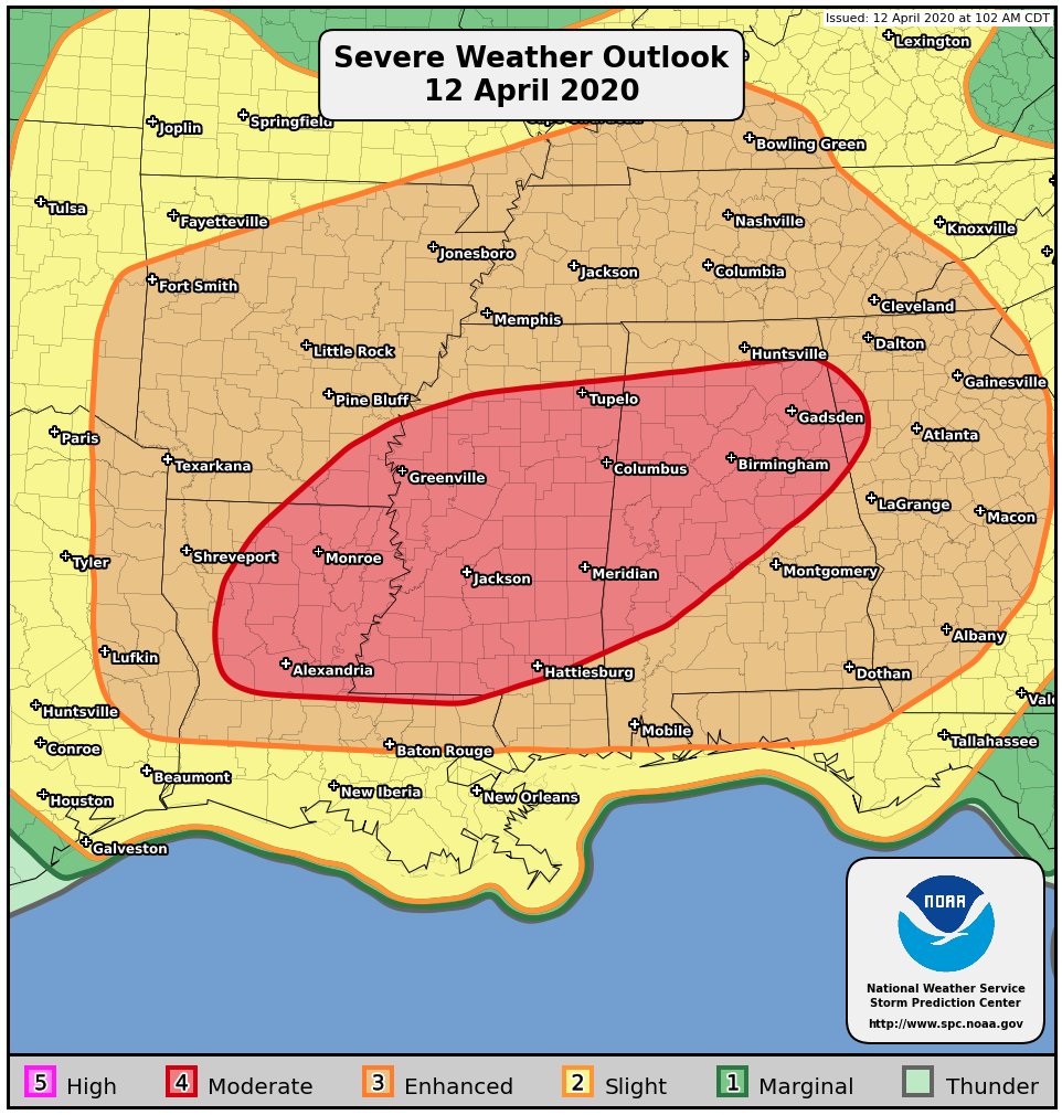
As of now most of MS is still under a moderate risk. There is going to be a morning round that may be marginally severe. When it clears out will determine the punch the second wave has when it fires up noon-2:00pm. When this one develops if it can stay discrete supercells then it will be a high end tornado event. If storm mode is messier then the tornado threat will still be more than present, but not to the degree it could be. The SPC updates at 1:00am and maybe learn some more then.
-
Originally Posted by
starkvegasdawg
For radar, I'd get RadarScope for your phone. The best $9.99 you will spend. Then if you want to get fancy you can upgrade to tier 1 for $9.99/year.
Is the basic RadarScope better than the free ones you get, like MyRadar and from television stations (many stations have their own radars also). They all show composites of the NEXRADS, where RS just shows one radar at a time. Does RS have better resolution or what is the advantage?
-
Originally Posted by
RocketDawg
Is the basic RadarScope better than the free ones you get, like MyRadar and from television stations (many stations have their own radars also). They all show composites of the NEXRADS, where RS just shows one radar at a time. Does RS have better resolution or what is the advantage?
RadarScope will show the warnings as well as velocity and the dual pol products. The one knock on RS is it does not do composite radar, but it's not that often that really comes into play.
-
What areas is the heavy stuff heading?
-
Originally Posted by
Uncle Ruckus
What areas is the heavy stuff heading?
Still too early to know. My personal guess is areas north of I-20...maybe Highway 84.
Last edited by starkvegasdawg; 04-12-2020 at 12:22 AM.
-
The next update from SPC is at 1 AM CT (06 ZULU). What I expect to see at this point is probably maintaining a Moderate (4/5) Risk category that may be slightly refined in area. The Day 1 outlook will provide us a good outlook on what we can expect. It seems that the models are in agreement about the fact that this will more than likely be a more linear system in the North end and a discrete cell system on the South end. However, the 00Z model runs should give a better idea (along with the high-res models that are extremely short range time-wise).
B.S. Geosciences, Professional Meteorology Concentration, Operational Emphasis
c/o 2015
Mississippi State University
@ColdSouthern911
Leicester City FC Owner
-
Maintaining moderate . same for ms. extended farther ne in alabama into corner of ga.

...ArkLaTex into the Southeast...
https://www.spc.noaa.gov/products/outlook/day1otlk.html
Initially, convection is expected to be ongoing across east TX this
morning, in association with a lead shortwave perturbation. Storm
mode may be messy with this area of convection as it spreads
east/northeast across northern LA/southern AR into northern MS and
the TN Valley vicinity. However, strong warm advection will bring
upper 60s to low 70s F dewpoints as far north as I-20 by late
morning/middday, as a 50+ kt southwesterly low level jet overspreads
the lower MS Valley. As a result, any convection that is initially
elevated above a modest EML should quickly become surface based.
Additional convection is then expected to develop by early afternoon
as a weak cap erodes across central and southern MS along a
pre-frontal trough/confluence band. These storms will likely be more
classic semi-discrete supercells, and spread eastward into AL by
late afternoon, and northern GA during the evening. Large, curved
hodographs and deep, rich boundary layer moisture in intense
vertical shear will support long-lived supercells capable of
producing significant tornadoes. Overnight, there is some potential
for upscale growth into a LEWP/QLCS across eastern AL/GA into the FL
Panhandle. Damaging wind and mesovortex tornadoes are possible with
this convective mode as well.
Last edited by ScoobaDawg; 04-12-2020 at 01:16 AM.
-
With SPC officially having this event as a Day 1 outlook, we will now get updates on this system from them every 6 hours or so. This also means that we are officially in the window for more...let's say technical....jargon being thrown around in discussions. We will try and decipher most of it into layman's terms. If you have any questions or concerns, I'll be in and out for the next 6 hours or so.
My biggest concerns may be realized if the SPC discussion is correct. The Lower MS valley is expected to get semi-discrete supercells that can pack a massive punch power-wise. These storms are expected to be through MS by mid to late afternoon. This means right when it's nice and warm, along with very humid, these cells will be feeding off of every bit of that energy. With that in mind, don't be surprised to see some of these cells pop off earlier (around midday). If the mid and low level instability continues to support development, all areas in the Moderate risk are well within the danger zone. Keep an eye out for updates and make sure your plans are in place. We will get through this together.
B.S. Geosciences, Professional Meteorology Concentration, Operational Emphasis
c/o 2015
Mississippi State University
@ColdSouthern911
Leicester City FC Owner
-
Senior Member

Thanks for this Ref.
I live in Tuscaloosa, what are your thoughts as this moves into my area?
-
Originally Posted by
runwildjerious
Thanks for this Ref.
I live in Tuscaloosa, what are your thoughts as this moves into my area?
T-Town is definitely in the zone for this. I would say we are at Spann-CON suspenders visible level for today. Sleeves aren't quite rolled up yet, but they may be unbuttoned. But really, keep an eye on what happens in East MS near Meridian. If anything does head that way, it'll follow the same track as 2011. Now, for clarification, I'm not saying this will be another April 2011 event. I don't think anything for a while will compare to that. But make your preparations, get your plan together, and keep an eye and ear on the radio/tv/etc.
B.S. Geosciences, Professional Meteorology Concentration, Operational Emphasis
c/o 2015
Mississippi State University
@ColdSouthern911
Leicester City FC Owner
-
-
Oh...wanted to make sure to add this. Tornadoes are NOT the only threat from this system. There will be considerable flash flooding and there will be high winds. How high? Can't really say but it'll be enough to destroy stuff. If you have anything planned outside for Easter, I'd reconsider if you're within the risk area. As always, pay attention to watches and warnings. Your local meteorologists and National Weather Service offices will have the best information.
B.S. Geosciences, Professional Meteorology Concentration, Operational Emphasis
c/o 2015
Mississippi State University
@ColdSouthern911
Leicester City FC Owner
-
04-12-2020, 01:38 AM
#100
Originally Posted by
TheRef
T-Town is definitely in the zone for this. I would say we are at Spann-CON suspenders visible level for today. Sleeves aren't quite rolled up yet, but they may be unbuttoned. But really, keep an eye on what happens in East MS near Meridian. If anything does head that way, it'll follow the same track as 2011. Now, for clarification, I'm not saying this will be another April 2011 event. I don't think anything for a while will compare to that. But make your preparations, get your plan together, and keep an eye and ear on the radio/tv/etc.
Will be interesting to see his thoughts in the morning on his daily video.
runwild.. stay safe.
 Posting Permissions
- You may not post new threads
- You may not post replies
- You may not post attachments
- You may not edit your posts
-
Forum Rules
Disclaimer: Elitedawgs is a privately owned and operated forum that is managed by alumni of Mississippi State University. This website is in no way affiliated with the Mississippi State University, The Southeastern Conference (SEC) or the National Collegiate Athletic Association (NCAA). The views and opinions expressed herein are strictly those of the post author and may not reflect the views of other members of this forum or elitedawgs.com. The interactive nature of the elitedawgs.com forums makes it impossible for elitedawgs.com to assume responsibility for any of the content posted at this site. Ideas, thoughts, suggestion, comments, opinions, advice and observations made by participants at elitedawgs.com are not endorsed by elitedawgs.com
Elitedawgs: A Mississippi State Fan Forum, Mississippi State Football, Mississippi State Basketball, Mississippi State Baseball, Mississippi State Athletics. Mississippi State message board.


 Reply With Quote