

-
Wednesday Severe Threat
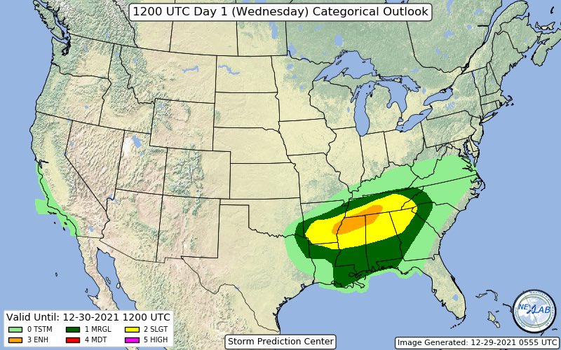
As of the 11:30 update the SPC left the threat level as slight. Models have trended towards a slightly weaker system the last couple of runs. That said, the afternoon and overnight might tend back stronger so enhanced is still not out of the question. The HRRR is still showing discrete cell formation but the NAM3k is more of a multicellular mode which goes along with the weakening trend. That said, any discrete cells that can form and maintain themselves will carry a tornado threat. There could be a morning and afternoon round of storms. Depending on the amount of morning storms, the afternoon round may be dampened some if the morning round can stabilize the atmosphere. But if the morning round is sparse and we get some breaks in the clouds then the afternoon/evening storms could be more potent. Main threat area for MS, I believe, will be east of I-55 and north of I-20 for the afternoon round and more the northern 1/3 of the state for the morning round.
-
Looks like a line is starting to Flare up along the river and another one to the west of LR,
-
Looks like chase mode will be activated for tomorrow. This is a very conditional set up that could go boom or bust. Latest HRRR is developing supercells as early as 6:00am over central and east central MS. These could easily be elevated in nature and not pose a tornado threat, but never say never. Closer to noon it develops more supercells over NW portions of the state and takes them ENE and north of tupelo and into TN. These could be more surfaced based and pose more of a tornado threat. It wasn't as bullish on another group of supercells over central MS late afternoon and moving into east MS but was showing additional development into west AL after dark. Any of these storms, if they form and become rooted in surface moisture could go severe and possibly tornadic. The SPC will update again around midnight and it will be interesting if they upgrade to enhanced and of the current slight risk area. I could see that over portions of north MS, NW AL, and southern TN. After tomorrow, then all eyes focus on Saturday and what could be a more significant event.
-
Weather forecast for Saturday High 74 Low 25. That is a definite recipe for Tornadoes.
-
Yall be carefull up there Flash Flood warning for West Point area
-

Originally Posted by
Leeshouldveflanked

Weather forecast for Saturday High 74 Low 25. That is a definite recipe for Tornadoes.
What is not in question is shear and instability. We will have plenty of both. What is potentially lacking are strong lapse rates (rate at which the atmosphere cools with altitude) and forcing (air rising at a faster rate than normal thermal buoyancy). The main dynamics of this system will be displaced north of the area. That's what's causing the question mark of whether or not supercells can form and sustain themselves. If they do, then they will be in an environment of ample shear to rotate and possibly go tornadic. One good thing is with the smaller lapse rates hail should not be a major concern tomorrow. The strongest storms should only be capable of 1" hail at the most.
-
Originally Posted by
starkvegasdawg
What is not in question is shear and instability. We will have plenty of both. What is potentially lacking are strong lapse rates (rate at which the atmosphere cools with altitude) and forcing (air rising at a faster rate than normal thermal buoyancy). The main dynamics of this system will be displaced north of the area. That's what's causing the question mark of whether or not supercells can form and sustain themselves. If they do, then they will be in an environment of ample shear to rotate and possibly go tornadic. One good thing is with the smaller lapse rates hail should not be a major concern tomorrow. The strongest storms should only be capable of 1" hail at the most.
Hopefully it fizzles. After seeing Smithville a few days afterward, I hope there is never another tornado anywhere.
-
Originally Posted by
Liverpooldawg
Hopefully it fizzles. After seeing Smithville a few days afterward, I hope there is never another tornado anywhere.
One silver lining for tomorrow is nothing like that is expected even in worst case scenario. 4/27/11 was just one of those days. Odds are the next time another event like that happens here we'll all be eating cream of wheat in a nursing home and trying to talk the hot nurse into giving us a sponge bath.
-
Originally Posted by
starkvegasdawg
One silver lining for tomorrow is nothing like that is expected even in worst case scenario. 4/27/11 was just one of those days. Odds are the next time another event like that happens here we'll all be eating cream of wheat in a nursing home and trying to talk the hot nurse into giving us a sponge bath.
I'll drink to that!
-
SPC has upgraded extreme northern MS to an enhanced risk for tomorrow. Mainly afternoon and evening. They are very suspect about the other storms posing much of a threat. We'll see if that changes. As it stands now I may be staging around the Batesville area tomorrow. One thing they did mention was that any storms that form after dark tomorrow over in AL could pose a severe risk. So if you have friends or family over there may want to let them know.
-
Originally Posted by
starkvegasdawg
SPC has upgraded extreme northern MS to an enhanced risk for tomorrow. Mainly afternoon and evening. They are very suspect about the other storms posing much of a threat. We'll see if that changes. As it stands now I may be staging around the Batesville area tomorrow. One thing they did mention was that any storms that form after dark tomorrow over in AL could pose a severe risk. So if you have friends or family over there may want to let them know.
Be careful man..... This thing looks sporadic and can build at any moment tomorrow.
-
Originally Posted by
defiantdog
Be careful man..... This thing looks sporadic and can build at any moment tomorrow.
Sporadic is a good word for it. More than likely my son will be going with me tomorrow. He's shown some interest in it. Told my wife he'll be perfectly safe and besides, I've only driven into 3 tornadoes while chasing. That got me a look but he's still going if he wants to.
-
Originally Posted by
starkvegasdawg
Sporadic is a good word for it. More than likely my son will be going with me tomorrow. He's shown some interest in it. Told my wife he'll be perfectly safe and besides, I've only driven into 3 tornadoes while chasing. That got me a look but he's still going if he wants to.
Love it!
-
Originally Posted by
starkvegasdawg
Sporadic is a good word for it. More than likely my son will be going with me tomorrow. He's shown some interest in it. Told my wife he'll be perfectly safe and besides, I've only driven into 3 tornadoes while chasing. That got me a look but he's still going if he wants to.
COW...... and another COW..... I think that was the same cow....
-
Originally Posted by
starkvegasdawg
Sporadic is a good word for it. More than likely my son will be going with me tomorrow. He's shown some interest in it. Told my wife he'll be perfectly safe and besides, I've only driven into 3 tornadoes while chasing. That got me a look but he's still going if he wants to.
Hey SVD, I have a few questions for you;
1. How old is your son, and did he go with you today?
2. Are you still planning on staging at Batesville, and if not, where?
3. What is your forecast estimation for the weather today?
Thanks so much, and of course, be safe!
-
It just don?t feel like it is warm enough up here in Union County at 11:30 am for Tornadoes? it?s kinda chilly right now
-
Originally Posted by
Leeshouldveflanked
It just don?t feel like it is warm enough up here in Union County at 11:30 am for Tornadoes? it?s kinda chilly right now
It should hear up in the next few hours to around 70. If you see sunlight then that's more fuel for the fire.
-
Originally Posted by
Dawg_Lover
Hey SVD, I have a few questions for you;
1. How old is your son, and did he go with you today?
2. Are you still planning on staging at Batesville, and if not, where?
3. What is your forecast estimation for the weather today?
Thanks so much, and of course, be safe!
He's 12
Greenwood
Could be rough. Still conditional.
Sorry for short answers but driving.
Last edited by starkvegasdawg; 12-29-2021 at 01:17 PM.
-
Originally Posted by
Leeshouldveflanked
It just don?t feel like it is warm enough up here in Union County at 11:30 am for Tornadoes? it?s kinda chilly right now
You're north of warm front. Almost 80 at Winona.
-
Originally Posted by
starkvegasdawg
He's 12
Greenwood
Could be rough. Still conditional.
Sorry for short answers but driving.
No, that is okay. I should have said I did not expect an answer until you only were settled and had a minute or two. Much appreciated.
* Foghorn Leghorn-isms *
> about as subtle as a hand grenade in a barrel of oatmeal.
> more mixed up than a feather in a whirlwind.
> gettin so deep the farmers have to jack up the cows so they can milk em.
> making more noise than a couple of skeletons dancing on a tin roof.
 Posting Permissions
- You may not post new threads
- You may not post replies
- You may not post attachments
- You may not edit your posts
-
Forum Rules
Disclaimer: Elitedawgs is a privately owned and operated forum that is managed by alumni of Mississippi State University. This website is in no way affiliated with the Mississippi State University, The Southeastern Conference (SEC) or the National Collegiate Athletic Association (NCAA). The views and opinions expressed herein are strictly those of the post author and may not reflect the views of other members of this forum or elitedawgs.com. The interactive nature of the elitedawgs.com forums makes it impossible for elitedawgs.com to assume responsibility for any of the content posted at this site. Ideas, thoughts, suggestion, comments, opinions, advice and observations made by participants at elitedawgs.com are not endorsed by elitedawgs.com
Elitedawgs: A Mississippi State Fan Forum, Mississippi State Football, Mississippi State Basketball, Mississippi State Baseball, Mississippi State Athletics. Mississippi State message board.


 Reply With Quote


