

-

Originally Posted by
starkvegasdawg

And just to add to the fun, both gfs and euro now saying snow for north MS early next week.
80 degree weather to lows in the 20s..... Sunday is looking to be an interesting day.
-
Originally Posted by
defiantdog
80 degree weather to lows in the 20s..... Sunday is looking to be an interesting day.
And Downward moved from the HWY 84 Tornado corridor to the North Mississippi crappy weather area.
-
Originally Posted by
parabrave
And Downward moved from the HWY 84 Tornado corridor to the North Mississippi crappy weather area.
Lol. Yeah, the severe weather here has sucked so far!!!! Dangit
-
Originally Posted by
defiantdog
80 degree weather to lows in the 20s..... Sunday is looking to be an interesting day.
There was an F-4 tornado here about 4:30 in the afternoon, November 1989. During the day highs were lower 80s; later that evening it was snowing. 22, I believe, were killed.
-
Just found out I'm going to be able to get off Tuesday so I'm now thinking of riding to Mempho. I live in the Tupelo area and would drive up Tuesday afternoon. What's the latest for North MS to Memphis corridor?
"The QB and the receiver weren't on the same page there, but hey its only week eleven". (Jack Cristil)
-
U are good for Tuesday. Wednesday might be another issue.
-
Originally Posted by
Saltydog
Just found out I'm going to be able to get off Tuesday so I'm now thinking of riding to Mempho. I live in the Tupelo area and would drive up Tuesday afternoon. What's the latest for North MS to Memphis corridor?
North Ms Corridor should be good, when you cross the state line beware of Gang Bangers, Car Jackers and Lot Lizards.
-
Originally Posted by
Leeshouldveflanked
North Ms Corridor should be good, when you cross the state line beware of Gang Bangers, Car Jackers and Lot Lizards.
No doubt. I pretty well know my way around Memphis. There are no "good" places. Just some places that are worse than others. I never stop anywhere on Lamar.
"The QB and the receiver weren't on the same page there, but hey its only week eleven". (Jack Cristil)
-
Originally Posted by
Saltydog
No doubt. I pretty well know my way around Memphis. There are no "good" places. Just some places that are worse than others. I never stop anywhere on Lamar.
Ain't no lie about that.
-
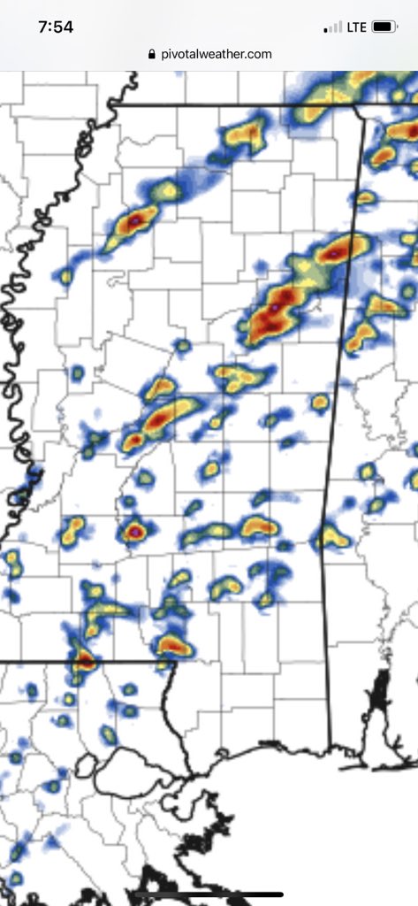
This is a simulated radar from the HRRR for Wednesday afternoon around 4:00. If storms materialize similar to this then I'll be concerned as this would be a group of discrete supercells that would almost assuredly be severe and some likely tornadic. That said, the local NWS offices are all far from sold on the Wednesday event as even this close in there are still significant model discrepancies. Hopefully, things become a lot clearer tomorrow.
-
Latest SPC update has kept the slight risk but mentioned they are considering an upgrade to enhanced if current trends continue. If the enhanced upgrade occurs, it will be for an increased tornado risk and allowing for the possibility of strong tornadoes. Looking at the latest HRRR I can't help but think this happens as it still shows several discrete supercells in an environment primed for severe storms and tornadoes. Next update is around 11:30 this morning. At that time I am probably going to create a new thread just for Wednesday and leave this one for the Saturday severe event and the cold air intrusion afterwards until closer to time.
-
The SPC has maintained the current slight risk for Saturday. They've also added a slight risk for Friday to include extreme NW MS. Even though they kept the slight for Saturday the wording they used is concerning. I'd be willing to bet the threat is upgraded to at least enhanced before we get to Saturday. While not yet certain, things are trying to shape up for a significant event for Saturday.
As for the white death following all the severe weather, the models are starting to back off that. But then don't they always?
-
Originally Posted by
starkvegasdawg
Latest SPC update has kept the slight risk but mentioned they are considering an upgrade to enhanced if current trends continue. If the enhanced upgrade occurs, it will be for an increased tornado risk and allowing for the possibility of strong tornadoes. Looking at the latest HRRR I can't help but think this happens as it still shows several discrete supercells in an environment primed for severe storms and tornadoes. Next update is around 11:30 this morning. At that time I am probably going to create a new thread just for Wednesday and leave this one for the Saturday severe event and the cold air intrusion afterwards until closer to time.
Looks like an enhanced risk might be given to the areas between tupelo and Memphis at 3pm.
-
Originally Posted by
defiantdog
Looks like an enhanced risk might be given to the areas between tupelo and Memphis at 3pm.
I'm expecting that even though the last run of the NAM3K backed off the discrete cells some. Fish out in an hour when I'm eating lunch at China Garden before taking my son to see Spider-Man.
-
SPC has left the slight risk and not upgraded for tomorrow. Models are now showing a weaker system than originally forecast.
-
Originally Posted by
starkvegasdawg
SPC has left the slight risk and not upgraded for tomorrow. Models are now showing a weaker system than originally forecast.
Which is good..... They moved the increased risk line up as well.
 Posting Permissions
- You may not post new threads
- You may not post replies
- You may not post attachments
- You may not edit your posts
-
Forum Rules
Disclaimer: Elitedawgs is a privately owned and operated forum that is managed by alumni of Mississippi State University. This website is in no way affiliated with the Mississippi State University, The Southeastern Conference (SEC) or the National Collegiate Athletic Association (NCAA). The views and opinions expressed herein are strictly those of the post author and may not reflect the views of other members of this forum or elitedawgs.com. The interactive nature of the elitedawgs.com forums makes it impossible for elitedawgs.com to assume responsibility for any of the content posted at this site. Ideas, thoughts, suggestion, comments, opinions, advice and observations made by participants at elitedawgs.com are not endorsed by elitedawgs.com
Elitedawgs: A Mississippi State Fan Forum, Mississippi State Football, Mississippi State Basketball, Mississippi State Baseball, Mississippi State Athletics. Mississippi State message board.


 Reply With Quote


