-
Tropical head's up - Hurricane IDA
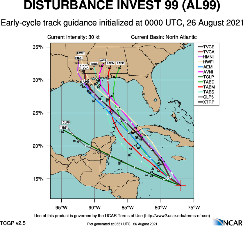
Looks like the Gulf may come alive early next week. There's currently a disturbance in the Caribbean that is forecast to become a closed low and gain tropical characteristics as it moves into the Gulf. Current forecast track and strengths are all over the place this far out but anywhere from New Orleans to Brownsville need to be keeping tabs on this as the potential...key word potential...is there for this to become a hurricane and possibly a major hurricane. The Gulf is currently a sauna with temps 85-90 degrees. We are now approaching the peak of the tropical Atlantic season so things getting active is to be expected.
-
Senior Member

Model run from Tropical Tidbits also show the system slowing down after landfall in Louisiana. If that pans out, there's going to be heavy amounts of rainfall in the state of Mississippi. But as you've stated, still a long way out.
-

Originally Posted by
Bodawg

Model run from Tropical Tidbits also show the system slowing down after landfall in Louisiana. If that pans out, there's going to be heavy amounts of rainfall in the state of Mississippi. But as you've stated, still a long way out.
I saw that. Last thing we need is another Harvey style tropical system that stalls out.
-
Latest batch of spaghetti models are starting to trend towards a more northern track of a potentially major hurricane. Still a lot of uncertainty on where it will end up and that will remain until it forms a closed low. That said, that looks to be starting to happen and signs may be pointing to what will be Ida taking a tour of the French Quarter.
-
Originally Posted by
starkvegasdawg
Latest batch of spaghetti models are starting to trend towards a more northern track of a potentially major hurricane. Still a lot of uncertainty on where it will end up and that will remain until it forms a closed low. That said, that looks to be starting to happen and signs may be pointing to what will be Ida taking a tour of the French Quarter.
go away every time you post weather i get deployed. 
-
Well Shit they keep shifting this thing East. Need it to ho back towards Lake Charles
-
-
Member
Thanks for the heads up Stark
-
Hey Stark, how of you feeling from your bout with the Kung Flu?
-
Oh, its hitting south Alabama, 100%. We can?t miss one. Already got a little crop damage from the last one. Long string of cuss words
-
Originally Posted by
CaptainObvious
Hey Stark, how of you feeling from your bout with the Kung Flu?
Doing pretty good. Still can't smell and get winded easily but all in all can't complain. Only thing that is under my skin now is I'm still under quarantine so if this storm ends up impacting the coast I won't be able to chase.
-
TD9 as of 10am. Projected to go in around from SW pass to Grand Island as a strong Cat 1.
-
Originally Posted by
parabrave
strong Cat 1.
I'm no weather expert, but I've been tracking hurricanes since around 2004. I know enough to know that this thing will, at some point, be stronger than CAT I. The only way that doesn't happen is if it gets torn to shreds crossing the mountains west of Havana and then moves fast enough that it doesn't have time to develop. The water temperatures are high, there's no shear, and it should spend a large amount of time over the eddy current loop currently in the GOM. All of the ingredients for rapid intensification are there. We'll have to get extremely lucky to thread the needle that doesn't lead to RI.
-
Originally Posted by
PMDawg
I'm no weather expert, but I've been tracking hurricanes since around 2004. I know enough to know that this thing will, at some point, be stronger than CAT I. The only way that doesn't happen is if it gets torn to shreds crossing the mountains west of Havana and then moves fast enough that it doesn't have time to develop. The water temperatures are high, there's no shear, and it should spend a large amount of time over the eddy current loop currently in the GOM. All of the ingredients for rapid intensification are there. We'll have to get extremely lucky to thread the needle that doesn't lead to RI.
I hate to agree with this, but I agree with this. The forecast models have had a hard time with the last few gulf storms with intensity. If I were to venture a guess right now I'm saying it ends up a mid range 3 at landfall.
-
This is beginning to look ugly.
-
Senior Member
Originally Posted by
PMDawg
I'm no weather expert, but I've been tracking hurricanes since around 2004. I know enough to know that this thing will, at some point, be stronger than CAT I. The only way that doesn't happen is if it gets torn to shreds crossing the mountains west of Havana and then moves fast enough that it doesn't have time to develop. The water temperatures are high, there's no shear, and it should spend a large amount of time over the eddy current loop currently in the GOM. All of the ingredients for rapid intensification are there. We'll have to get extremely lucky to thread the needle that doesn't lead to RI.
Early intensity models are almost always total garbage, especially for storms crossing the central gulf. I'd fully expect a major hurricane. By the way, just saw an early model suggesting another storm following this one about a week later and also hitting Louisiana.
-
Arrow....been a long, long time
-
Originally Posted by
Indndawg
Arrow....been a long, long time
Too long
-
Time line on this thing??!
-
Originally Posted by
DownwardDawg
Time line on this thing??!
LA coast around Sun - Monday morn
 Posting Permissions
- You may not post new threads
- You may not post replies
- You may not post attachments
- You may not edit your posts
-
Forum Rules
Disclaimer: Elitedawgs is a privately owned and operated forum that is managed by alumni of Mississippi State University. This website is in no way affiliated with the Mississippi State University, The Southeastern Conference (SEC) or the National Collegiate Athletic Association (NCAA). The views and opinions expressed herein are strictly those of the post author and may not reflect the views of other members of this forum or elitedawgs.com. The interactive nature of the elitedawgs.com forums makes it impossible for elitedawgs.com to assume responsibility for any of the content posted at this site. Ideas, thoughts, suggestion, comments, opinions, advice and observations made by participants at elitedawgs.com are not endorsed by elitedawgs.com
Elitedawgs: A Mississippi State Fan Forum, Mississippi State Football, Mississippi State Basketball, Mississippi State Baseball, Mississippi State Athletics. Mississippi State message board.


 Reply With Quote