

-
Next Severe Threat on the Horizon?
Next Thursday the CIPS analogs and the GFS is showing a severe threat for most of MS. Now 7 days out in weather is an eternity so don't go changing plans yet. Just a thought to keep in the back of your mind. And while you're tucking away thoughts tuck one away that there are some hints this may end up being a multi-day severe threat. We are now heading into the peak of our severe weather season in Dixie Alley so this is pretty typical.
Last edited by starkvegasdawg; 04-01-2021 at 01:06 PM.
-
Well, if I recall correctly, the models have been pretty much on for 7 days out. They were not necessarily pin pointedly accurate, but certainly were with approximate timing and general area. In fact, in last weeks severe events, the short term models just a few hours out were off a little, with the "high" areas of concern being most of north Mississippi and north Alabama - but the actual tornadic weather was the worst south of Birmingham. So even the short term models aren't exactly right in the very near term. But, the long term models are impressively accurate, so we should count on severe weather of some type in the mid-South next week if the models indicate that.
-
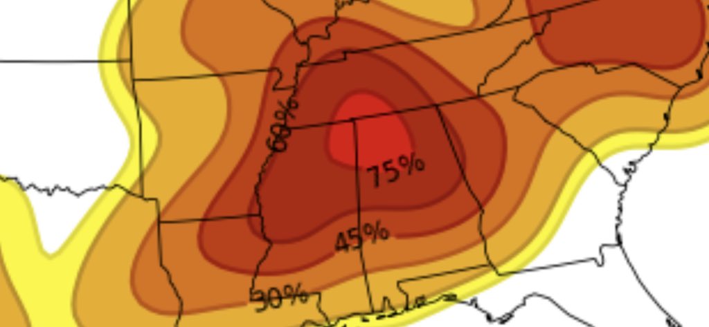
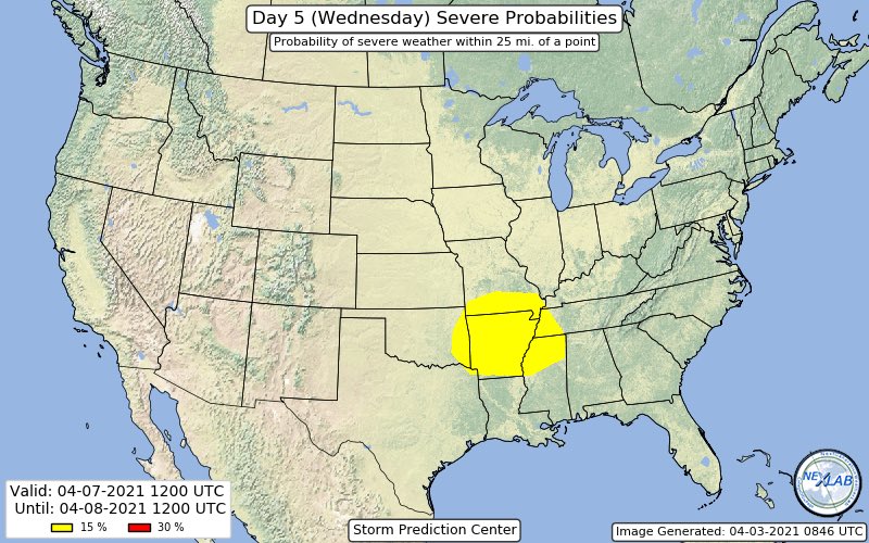
SPC has now highlighted a severe threat area for Wednesday.
-
Any new updates? Looking like most of the energy coming through late afternoon into the evening as of now.
-
Dam looks like Late Thrus and Friday with 2 waves going through central MS.
https://www.tropicaltidbits.com/anal...frzn_us_15.png
-
We have been planning to head up to Starkville / West Point Wednesday night thru Saturday. Looking like that?s probably not going to be a great place to be at that time.
-
Haven't looked too closely at things today, but as of now it's looking like more of a low end severe event with the main threats being hail and straight line winds for Wednesday night and Thursday. There will be a tornado threat but as of right now it's not looking overly significant. As for the rest of the weekend, the analogs are showing possible severe weather but there's such a huge spread with the models confidence is extremely low on nailing anything down. Some are showing storms and some dry weather. Main take away is unless something drastic changes the middle to end of this week is looking nothing like the last two severe events we had. Which is good as my truck is still sick in the shop and won't be out until the end of this week.
-

Originally Posted by
starkvegasdawg

Haven't looked too closely at things today, but as of now it's looking like more of a low end severe event with the main threats being hail and straight line winds for Wednesday night and Thursday. There will be a tornado threat but as of right now it's not looking overly significant. As for the rest of the weekend, the analogs are showing possible severe weather but there's such a huge spread with the models confidence is extremely low on nailing anything down. Some are showing storms and some dry weather. Main take away is unless something drastic changes the middle to end of this week is looking nothing like the last two severe events we had. Which is good as my truck is still sick in the shop and won't be out until the end of this week.
I get to travel to Jackson on Thursday morning for business. Huzzah!
-
Vegas or anyone have any updates on this? I see there?s a decent chance of rain Thursday through Saturday.
-
Originally Posted by
TimberBeast
Vegas or anyone have any updates on this? I see there?s a decent chance of rain Thursday through Saturday.
A severe threat does look to materialize late Wednesday afternoon across eastern AR and progress across MS late evening and into the overnight. Storm mode is looking to quickly congeal into a qlcs and being mainly damaging straight line winds, but there is a chance to get a few spin up tornadoes. Beyond this the jury is still out on this weekend. There are some hints a more significant severe weather event could unfold in the Friday/Saturday timeframe but as of right now there isn't enough model consensus to say for sure.
-
Originally Posted by
starkvegasdawg
A severe threat does look to materialize late Wednesday afternoon across eastern AR and progress across MS late evening and into the overnight. Storm mode is looking to quickly congeal into a qlcs and being mainly damaging straight line winds, but there is a chance to get a few spin up tornadoes. Beyond this the jury is still out on this weekend. There are some hints a more significant severe weather event could unfold in the Friday/Saturday timeframe but as of right now there isn't enough model consensus to say for sure.
I see that Harrison County is forecasted to have a gulley washer Sat. Now it looks 20 and south
-
Jackson NWS just released a graphic mentioning the possibility of significant severe weather for Friday. It's not a slam dunk yet, but said a lot of the parameters are coming together to get their attention.
-
About how far south into MS is that expected? I saw parabrave said rain down to the coast.
-
How we looking in the AM Thursday thru Saturday? Need to know if i need to bring the wet gear in the woods
-
Originally Posted by
TimberBeast
About how far south into MS is that expected? I saw parabrave said rain down to the coast.
This far.
https://www.tropicaltidbits.com/anal...frzn_us_16.png
Sorry link not working
Its going to be a stormy Saturday on the Coast
-
Originally Posted by
BuckyIsAB****
How we looking in the AM Thursday thru Saturday? Need to know if i need to bring the wet gear in the woods
Thursday should be somewhat dry. Friday looks...interesting. Saturday should be ok as it looks now.
-
Originally Posted by
starkvegasdawg
Thursday should be somewhat dry. Friday looks...interesting. Saturday should be ok as it looks now.
Friday morning? Hope not
-
Originally Posted by
BuckyIsAB****
Friday morning? Hope not
More afternoon for the main event but saying could be some scattered morning stuff.
-
Originally Posted by
starkvegasdawg
More afternoon for the main event but saying could be some scattered morning stuff.
Thanks man. You guys are the real MVPs around here
-
Originally Posted by
starkvegasdawg
Thursday should be somewhat dry. Friday looks...interesting. Saturday should be ok as it looks now.
Any thoughts on Sylacauga, AL Saturday morning? I will be there for a race.
 Posting Permissions
- You may not post new threads
- You may not post replies
- You may not post attachments
- You may not edit your posts
-
Forum Rules
Disclaimer: Elitedawgs is a privately owned and operated forum that is managed by alumni of Mississippi State University. This website is in no way affiliated with the Mississippi State University, The Southeastern Conference (SEC) or the National Collegiate Athletic Association (NCAA). The views and opinions expressed herein are strictly those of the post author and may not reflect the views of other members of this forum or elitedawgs.com. The interactive nature of the elitedawgs.com forums makes it impossible for elitedawgs.com to assume responsibility for any of the content posted at this site. Ideas, thoughts, suggestion, comments, opinions, advice and observations made by participants at elitedawgs.com are not endorsed by elitedawgs.com
Elitedawgs: A Mississippi State Fan Forum, Mississippi State Football, Mississippi State Basketball, Mississippi State Baseball, Mississippi State Athletics. Mississippi State message board.


 Reply With Quote
