

-
Mema has activated all MS Task Forces and Urban Search and Rescue Teams. That?s all the updates you need. Get ready and stay alert. NWS briefing at 12:30 to mema had timing between 6-midnight.
-
1st Torn warnings along a line HWy 84 Laurel east to south of Quitman to Demolopis
-
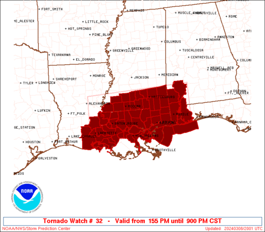
First tornado is on the ground SE Mississippi. A PDS tornado watch is in effect for most of East and Central Mississippi. Shortly, a new PDS watch will be issued for the Mississippi Delta region, including Jackson and the entire ArkLaMiss area. This is not a fun situation to be in, and definitely not one to take likely. I will try to keep y'all updated in here, but I can only do so much from a distance and I'll be on duty soon at my own work.
B.S. Geosciences, Professional Meteorology Concentration, Operational Emphasis
c/o 2015
Mississippi State University
@Norwoodwx
Leicester City FC Owner
-
The tornado in Wayne County is CONFIRMED. Damage being reported to homes already from this one, and it is still on the ground.
B.S. Geosciences, Professional Meteorology Concentration, Operational Emphasis
c/o 2015
Mississippi State University
@Norwoodwx
Leicester City FC Owner
-
Hey SVD are you up on Twitt
-

Originally Posted by
parabrave

Hey SVD are you up on Twitt
BTW happy BD
-
Tornado warning for the Shubuta area seems to no longer have one on the ground at this time, but the warning is still active. It could still restrengthen and drop one without notice. The cell near Quitman has some strong rotation and is showing signs that it either has one on the ground, or is about to drop one.
B.S. Geosciences, Professional Meteorology Concentration, Operational Emphasis
c/o 2015
Mississippi State University
@Norwoodwx
Leicester City FC Owner
-
Originally Posted by
parabrave
Hey SVD are you up on Twitt
Not streaming. Our team is using Patreon streaming on YouTube.
-
CONFIRMED tornado on the ground in Autauga County, AL. East of Valley Grand, moving NE at 30 MPH.
Tornado Debris Signature is present, it's actively on the ground.
B.S. Geosciences, Professional Meteorology Concentration, Operational Emphasis
c/o 2015
Mississippi State University
@Norwoodwx
Leicester City FC Owner
-
That cell north of Cuba looks like it's on a direct path towards Tuscalossa.
-
Tornado Warning for Copiah, Lincoln, and Lawrence counties. Radar Indicated. Located around Bogue Chitto right now, moving NE at 30 MPH
B.S. Geosciences, Professional Meteorology Concentration, Operational Emphasis
c/o 2015
Mississippi State University
@Norwoodwx
Leicester City FC Owner
-
PDS watch is out. Looks like it is the rest of Mississippi that wasn't under the other PDS tornado watch.
B.S. Geosciences, Professional Meteorology Concentration, Operational Emphasis
c/o 2015
Mississippi State University
@Norwoodwx
Leicester City FC Owner
-
Rotation in the Lincoln county cell is still looking very strong. Concerning, to say the least.
B.S. Geosciences, Professional Meteorology Concentration, Operational Emphasis
c/o 2015
Mississippi State University
@Norwoodwx
Leicester City FC Owner
-
Two reports of a funnel cloud near Hwy 84 in Eastern Lincoln County, just east of Brookhaven. This one is close. Keep your ears on the ground
B.S. Geosciences, Professional Meteorology Concentration, Operational Emphasis
c/o 2015
Mississippi State University
@Norwoodwx
Leicester City FC Owner
-
Tornado Debris Signature on the Brookhaven storm, CONFIRMED tornado.
B.S. Geosciences, Professional Meteorology Concentration, Operational Emphasis
c/o 2015
Mississippi State University
@Norwoodwx
Leicester City FC Owner
-
Tornado warning for Jones County. Cell is near Ovett and Ellisville. Moving NE at 35 MPH
B.S. Geosciences, Professional Meteorology Concentration, Operational Emphasis
c/o 2015
Mississippi State University
@Norwoodwx
Leicester City FC Owner
-
New tornado warning for the Ellisville area. Moving NE at 35 MPH
B.S. Geosciences, Professional Meteorology Concentration, Operational Emphasis
c/o 2015
Mississippi State University
@Norwoodwx
Leicester City FC Owner
-
-
Also, tornado warning is in effect down near Waynesboro
B.S. Geosciences, Professional Meteorology Concentration, Operational Emphasis
c/o 2015
Mississippi State University
@Norwoodwx
Leicester City FC Owner
-
Originally Posted by
TheRef
Two reports of a funnel cloud near Hwy 84 in Eastern Lincoln County, just east of Brookhaven. This one is close. Keep your ears on the ground
I just outran that bad boy down 84!!! I was watching radar and knew it was right there.
 Posting Permissions
- You may not post new threads
- You may not post replies
- You may not post attachments
- You may not edit your posts
-
Forum Rules
Disclaimer: Elitedawgs is a privately owned and operated forum that is managed by alumni of Mississippi State University. This website is in no way affiliated with the Mississippi State University, The Southeastern Conference (SEC) or the National Collegiate Athletic Association (NCAA). The views and opinions expressed herein are strictly those of the post author and may not reflect the views of other members of this forum or elitedawgs.com. The interactive nature of the elitedawgs.com forums makes it impossible for elitedawgs.com to assume responsibility for any of the content posted at this site. Ideas, thoughts, suggestion, comments, opinions, advice and observations made by participants at elitedawgs.com are not endorsed by elitedawgs.com
Elitedawgs: A Mississippi State Fan Forum, Mississippi State Football, Mississippi State Basketball, Mississippi State Baseball, Mississippi State Athletics. Mississippi State message board.


 Reply With Quote


