

-
Severe Weather Expected Monday Night
Severe weather, with all modes possible, looking likely for Monday night into Tuesday morning. Right now, central and south MS looking to see the best chance where an upgrade to an enhanced threat is expected tonight.
Detailed write up below. For those on FB, please like, share, and maybe even leave a comment on this post. It helps us get a little bit more of Zuckerburg's money and is free for you. However, those feeling especially generous, you can go to www.NMSCAS.org and donate to our non-profit which helps us fund our community outreach programs and continue to do our crazy storm chaser stuff.
https://www.facebook.com/share/p/xnUhvrndPtHEBKJQ/?
-
Well that forecast changed overnight. Wasn't expecting it all the way down to the coast.
-

Originally Posted by
parabrave

Well that forecast changed overnight. Wasn't expecting it all the way down to the coast.
The big question has always been whether another low pressure would rob all the moisture advecting north. It's now looking like that isn't going to be the case so it's game on. How far north it ends up will depend on how far north we can get mid 60 dew points.
-
-
Originally Posted by
WinningIsRelentless
Latest?
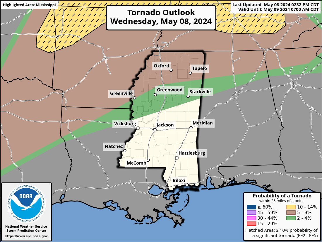
The western part of the state was upgraded to an enhanced risk this afternoon with the southwest part of the state placed under a 10% hatched risk for significant tornadoes. Timing looks to roughly be from 4:00pm to 3:00am.
-
Monday night from Southhaven to Biloxi going to be rough. According to the European 3 bad pockets are the Wiggins to Laurel, including CC24 Land, and Starkville area. The GFS is from 20 north. But a Squall line will be affecting the entire state Monday night/Tues morning. Of course these are always subject to change. Check back tomorrow around noon.
-
One bit of good news is wind profiles seem to favor a QLCS (squall line) and not discrete storms. That will help reduce the tornado threat. There's a couple other limiting factors, but that is the biggest. This is what is called a low CAPE / high shear set up.
-
Senior Member

Originally Posted by
starkvegasdawg
One bit of good news is wind profiles seem to favor a QLCS (squall line) and not discrete storms. That will help reduce the tornado threat. There's a couple other limiting factors, but that is the biggest. This is what is called a low CAPE / high shear set up.
That's mainly what I expect to see, a squall line with possible embedded spin-ups. Regardless, damaging winds are certainly a high risk and never to be taken lightly.
-
Originally Posted by
ArrowDawg
That's mainly what I expect to see, a squall line with possible embedded spin-ups. Regardless, damaging winds are certainly a high risk and never to be taken lightly.
Jsut keep in mind even with spin ups, a few in SW MS could be strong.
-
-
Originally Posted by
CaptainObvious
Hail size expected?
Hail will not be a major concern with this system. Lapse rates are not particularly impressive so hail size will be limited. It should max out around quarter size in the strongest storms.
-
If anyone has the time and wants to see a good light show tune into the MDOT cameras at VKS, Greenville and the other MISS River crossing up near Tunica. You can get some great views when there are storms headed east across the LA/Ark delta.
-
Also, just a reminder, if anyone is feeling generous you can support our team's non-profit by texting NMSC to 53555 or go to www.nmscas.org. In addition to helping us do the crazy storm chasing stuff we do, we also are gearing up to provide disaster relief supplies to areas when they are affected by severe weather and have already launched a campaign where we are donating weather radios to childcare facilities and nursing homes. So far we've donated 19 radios.
-
Severe threat has been pulled east. Threat for strong tornadoes now covers all of central MS. Only a squall line is expected so tornadoes would be embedded in the line. Strong tornadoes are possible.
-
Junior Member
Is Hattiesburg just south of the possibility of a strong Tornado?
-
Originally Posted by
Foxdog
Is Hattiesburg just south of the possibility of a strong Tornado?
Not enough to matter.
-
Originally Posted by
starkvegasdawg
Severe threat has been pulled east. Threat for strong tornadoes now covers all of central MS. Only a squall line is expected so tornadoes would be embedded in the line. Strong tornadoes are possible.
Great.....
-
Originally Posted by
DownwardDawg
Great.....
Yup, I'm right below the "a" in Hattiesburg. Working days of course, so short sleep tonight. Both sons' live close enough that we all use the same storm shelter. It's nice to have, but I get antsy when all the kids and grandkids pile in there. Not claustrophobic, 8 years riding subs to show that, just too many people in a small space.
If it ain't broke, fix it til it is.
-
Should have been in Madison and Canton tonight. Exciting to say the least! I don’t think there was any damage in the area, but my power has been flickering.
-
Senior Member
Originally Posted by
Extendedcab
Should have been in Madison and Canton tonight. Exciting to say the least! I don’t think there was any damage in the area, but my power has been flickering.
Had a close call here in Clinton.
 Posting Permissions
- You may not post new threads
- You may not post replies
- You may not post attachments
- You may not edit your posts
-
Forum Rules
Disclaimer: Elitedawgs is a privately owned and operated forum that is managed by alumni of Mississippi State University. This website is in no way affiliated with the Mississippi State University, The Southeastern Conference (SEC) or the National Collegiate Athletic Association (NCAA). The views and opinions expressed herein are strictly those of the post author and may not reflect the views of other members of this forum or elitedawgs.com. The interactive nature of the elitedawgs.com forums makes it impossible for elitedawgs.com to assume responsibility for any of the content posted at this site. Ideas, thoughts, suggestion, comments, opinions, advice and observations made by participants at elitedawgs.com are not endorsed by elitedawgs.com
Elitedawgs: A Mississippi State Fan Forum, Mississippi State Football, Mississippi State Basketball, Mississippi State Baseball, Mississippi State Athletics. Mississippi State message board.


 Reply With Quote


