-
Tornado threat????? Experts..........
How serious is the threat around the Hsttiesburg area tonight?
-
Senior Member


I'd like to know too. It's hot here in the Burg.
-
-
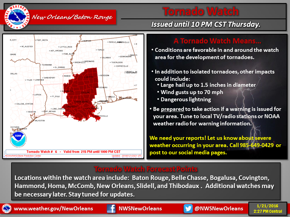
Tornado Warning for...
western Franklin County in southwestern Mississippi...
east Central Adams County in southwestern Mississippi...
southeastern Jefferson County in southwestern Mississippi...
* until 415 PM CST
* at 321 PM CST... a severe thunderstorm capable of producing a
tornado was located over Kingston... or 12 miles southeast of
Natchez... moving northeast at 30 mph.
Hazard... tornado.
Source... radar indicated rotation.
Impact... flying debris will be dangerous to those caught without
shelter. Mobile homes will be damaged or destroyed.
Damage to roofs... windows and vehicles will occur. Tree
damage is likely.
* This dangerous storm will be near...
Garden City around 330 PM CST.
Cranfield around 335 PM CST.
Hamburg around 350 PM CST.
Kirby around 355 PM CST.
McNair around 400 PM CST.
New Hope around 410 PM CST.
Other locations impacted by this tornadic thunderstorm include
Meadville and Roxie.
Precautionary/preparedness actions...
Take cover now! Move to a basement or an interior room on the lowest
floor of a sturdy building. Avoid windows. If you are outdoors... in a
Mobile home... or in a vehicle... move to the closest substantial
shelter and protect yourself from flying debris.
Lat... Lon 3133 9114 3135 9115 3134 9115 3135 9116
3135 9117 3156 9121 3175 9093 3152 9076
3133 9112
time... Mot... loc 2121z 234deg 26kt 3141 9124
Tornado... radar indicated
hail... <.75in
-
Mississippi Weather @SimpleWeatherMS 1m1 minute ago
Potential Tornado Near New Hope or 25 Miles West of Brookhaven Moving NE At 35 MPH. Large Hail. Flying Debr... #mswx http://www.
-
Thanks scooba. Keep it coming. I'm in the woods in Covington county and my son is the the Burg. Gotta go get him tonight.
-

Originally Posted by
DownwardDawg

Thanks scooba. Keep it coming. I'm in the woods in Covington county and my son is the the Burg. Gotta go get him tonight.
3 tornado warnings from meadville to union charge over to just below brandon / puckett line right now.
2 more in Louisiana, Wakefield and Lakeland... those are the ones you will both need to watch
-
Main threat area will basically be an area from Baton Rouge to Jackson for the next couple hours. I've seen several storms with good tight rotation but have not heard of any confirmed reports. Don't remember seeing any debris signatures on radar either.
-
Thanks guys. Climbed down. The wind was brutal and the distant thunder was on my mind!
 Posting Permissions
- You may not post new threads
- You may not post replies
- You may not post attachments
- You may not edit your posts
-
Forum Rules
Disclaimer: Elitedawgs is a privately owned and operated forum that is managed by alumni of Mississippi State University. This website is in no way affiliated with the Mississippi State University, The Southeastern Conference (SEC) or the National Collegiate Athletic Association (NCAA). The views and opinions expressed herein are strictly those of the post author and may not reflect the views of other members of this forum or elitedawgs.com. The interactive nature of the elitedawgs.com forums makes it impossible for elitedawgs.com to assume responsibility for any of the content posted at this site. Ideas, thoughts, suggestion, comments, opinions, advice and observations made by participants at elitedawgs.com are not endorsed by elitedawgs.com
Elitedawgs: A Mississippi State Fan Forum, Mississippi State Football, Mississippi State Basketball, Mississippi State Baseball, Mississippi State Athletics. Mississippi State message board.


 Reply With Quote