

-
Ask TheRef
So I decided to create this thread so I can help y'all understand any Meteorological stuff you want to know.
I will try to provide links to everything I answer so that you can read up further on it.
B.S. Geosciences, Professional Meteorology Concentration, Operational Emphasis
c/o 2015
Mississippi State University
@Norwoodwx
Leicester City FC Owner
-
You do realize what you just opened yourself up for don't you?
Allow me to adequately warm my fingers up...
1. Is surface to 500mb crossover the same thing as shear vectors? If not, where can I go to find shear vectors?
2. Tell me again what values and at what altitudes I need to look at for relative vorticity and vertical velocity?
3. Thinking about targeting west TN this Friday. Your thoughts on that area.
I'm sure I will come up with a ton more but that'll get me started on something to ponder over.
-

Originally Posted by
starkvegasdawg

You do realize what you just opened yourself up for don't you?
Allow me to adequately warm my fingers up...
1. Is surface to 500mb crossover the same thing as shear vectors? If not, where can I go to find shear vectors?
2. Tell me again what values and at what altitudes I need to look at for relative vorticity and vertical velocity?
3. Thinking about targeting west TN this Friday. Your thoughts on that area.
I'm sure I will come up with a ton more but that'll get me started on something to ponder over.
1. That is not the same thing for shear vectors. You can find shear vectors for just about any range of levels. A site that I would use for shear vectors is twisterdata.com . That site will usually have anything you want to see for storm chasing purposes in a fairly easy to find manner.
2. Relative Vorticity is found at 500 mb, Vertical Velocities are at 700 mb.
3. I've looked at it, and I think this is more of a squall line event associated with a boundary. You should get some straight line wind events, and maybe some embedded rain-wrapped tornadoes. But nothing that you want to be chasing for sure.
B.S. Geosciences, Professional Meteorology Concentration, Operational Emphasis
c/o 2015
Mississippi State University
@Norwoodwx
Leicester City FC Owner
-
Thanks. I've been on twister data. All I found was cross over and bulk shear from the surface up to a certain mb. Is that shear vector? I've looking at that forever since I found the site.
-
Originally Posted by
starkvegasdawg
Thanks. I've been on twister data. All I found was cross over and bulk shear from the surface up to a certain mb. Is that shear vector? I've looking at that forever since I found the site.
Yeah...that's bulk shear
B.S. Geosciences, Professional Meteorology Concentration, Operational Emphasis
c/o 2015
Mississippi State University
@Norwoodwx
Leicester City FC Owner
-
Explain all of these for me:
1. Ball lightning
2. St. ELmo's Fire
3. Fire Whirls
4. Red Sprites and Blue Jets
5. Snow Donuts
6. Non-aqueous rain
7. giant hailstones
8. super cells
9. Katabatic winds
10. Gravity waves
-
Originally Posted by
BulldogDX55
Explain all of these for me:
1. Ball lightning
2. St. ELmo's Fire
3. Fire Whirls
4. Red Sprites and Blue Jets
5. Snow Donuts
6. Non-aqueous rain
7. giant hailstones
8. super cells
9. Katabatic winds
10. Gravity waves
Okay...I'll do what I can.
1. Ball Lighting (http://en.wikipedia.org/wiki/Ball_lightning): The explanation as to why ball lightning occurs is still under consideration by many studies, and doesn't look like it will be easy to figure out what exactly causes this phenomenon. The version that is being most widely accepted right now is the vaporized silicon hypothesis. This says that when lightning strikes the earth, it separates the silicon found on the Earth's surface (trace amounts of course), then it will separate the oxygen from Silicon Dioxide, thus creating the cloud of silicon that glows due to the rapid oxidation of the substance.
2. St. Elmo's Fire (http://en.wikipedia.org/wiki/St._Elmo%27s_fire): Now St Elmo's Fire is often confused with Ball Lightning, but this only appears on tall, sharp objects such as masts, lightning rods, towers, etc. St. Elmo's Fire (I'm going to call it SEF from now on so I don't have to keep typing it) is in the form of Plasma. Plasma is found in stars, high temperature flames, and lightning. SEF usually appears due to the intense electrical field surrounding the object ionizing the molecules. Depending on the molecules surrounding it and the concentration of those said molecules, that determines the color of SEF.
3. Fire Whirls (http://en.wikipedia.org/wiki/Fire_whirl): While these are usually called Fire Tornadoes, these are not actually tornadoes. Think of them more as dirt-devils, or the like. These are created due to the instability of the air surrounding flames as the hot, less dense air looks to rise rapidly into a more stable, denser state. This instability and the turbulent winds associated with fires will sometimes combine to create these whirls of flame. They're really cool looking, and can be dangerous if left to their own devices, but these rarely, if ever, transition into a full tornado form.
4. Red Sprites and Blue Jets (http://en.wikipedia.org/wiki/Upper-a...ic_lightning): So these are similar to the aurora borealis, and the like. Red Sprites and Blue Jets are found in the upper atmosphere and are cause by electromagnetic pulses found in the upper tropo and mesospheres.
5. Snow Donuts (http://en.wikipedia.org/wiki/Snow_roller): I actually didn't even know about this type of phenomena until I read up on it. Basically what you need for a snow roller is a relatively thin layer of wet snow near the melting point, then you need either a thin layer of ice or dry snow under it, you need a perfect wind that will be able to roll it, but not rip it apart, or you can have gravity do the work for you on a slight decline.
6. Non-aqueous rain (http://www.fiboni.com/2013/08/non-aq...s-but-water/): The reasons behind this are very inconclusive, but you can usually attribute this type of phenomena to tornadoes and/or waterspouts as they pick up things other than water droplets, and toss them elsewhere. But who knows...I mean...spiders have fallen from the sky before in Argentina 2007.

7. Giant Hailstones: Now Giant Hailstones are usually just due to an intense updraft in which a hailstone is consistently tossed up, allowed to sink to melt the outer layer, then picked up again. Over and over and over again this happens, and usually speaks of an ultra stable supercell that is capable of tossing these stones up and down without ever having it drop below the cloud deck.
8. Supercells: So these are basically the baddest of the bad in terms of single-cell storms. These cells are fed from the SE by a warm, moist inflow, then the outflow is usually to the West of the storm (rear-flank downdraft or RFD). If you've ever been in an RFD, and trust me you would know, you would feel an intense and cold wind as it came down. This is due to the rain-cooled air of the supercell getting kicked out behind so that the storm doesn't choke itself off. Supercells are tilted that way the warm moist air isn't choked off by the cool, dry air of the outflow. As long as this tilt is maintained, you will have a supercell.
9. Katabatic Winds (http://en.wikipedia.org/wiki/Katabatic_wind): Okay...so a Katabatic wind is usually just associated with winds coming from a higher elevation to a lower elevation quickly. This is usually associated with differential surface heating at the top of a mountain, along with air that has been forced up the mountain throughout the day due to instability below causing particles to rise. As the day transitions into night, the air that has been forced up the mountain, has to go down somehow. This means you have an intense rush of cool, dry air being forced right back down the mountain at breakneck speeds. Usually, though, the winds are only going at about 10 mph.
10. Gravity Waves (http://en.wikipedia.org/wiki/Gravity_wave): Gravity waves are basically what occurs after there is a large difference in densities in which gravity tries to fix.
B.S. Geosciences, Professional Meteorology Concentration, Operational Emphasis
c/o 2015
Mississippi State University
@Norwoodwx
Leicester City FC Owner
-
Senior Member


Do they still think tornadoes might be cause by horizontally spinning turbulence (or shear) that gets tilted vertical by updrafts? Saw a professional weather nerd float that hypothesis in a skywarn class many years ago.
-
Difference in an elevated storm and surface based storm.
-
Originally Posted by
FlabLoser
Do they still think tornadoes might be cause by horizontally spinning turbulence (or shear) that gets tilted vertical by updrafts? Saw a professional weather nerd float that hypothesis in a skywarn class many years ago.
That is a possibility. No one truly knows, and we might not ever know. That's what meteorologists and atmospheric scientists are trying to figure out at this time. But what you're thinking of are parallel rotating columns of air that are lifted vertical due to the updraft of a storm.
That is only a theory, and hasn't been confirmed yet.
-
Saw that Memphis NWS is now specifically mentioning tornadoes as being possible for north MS and SW TN for tomorrow afternoon. I'm guessing (hoping) before everything congeals into a QLCS. What is strange is that the new enhanced risk area seems to be slightly displaced from the mentioned tornado threat area. Really hoping for some model consensus this evening.
-
Originally Posted by
TheRef
Okay...I'll do what I can.
I was trolling, man.
I googled "unexplainable meteorology phenomenon" and a list popped up.
Edit: Also, were you at Dave's for trivia last night? I think I know who you are.
-
Originally Posted by
BulldogDX55
I was trolling, man.
I googled "unexplainable meteorology phenomenon" and a list popped up.
Edit: Also, were you at Dave's for trivia last night? I think I know who you are.
I was...I was the redhead at the table of about 7 people.
B.S. Geosciences, Professional Meteorology Concentration, Operational Emphasis
c/o 2015
Mississippi State University
@Norwoodwx
Leicester City FC Owner
-
Any idea what is causing the storm tracks to be so far north so early? Almost seems like we're in a late May/early June pattern instead of early April. Beginning to think this storm season may pass us by.
-
Originally Posted by
starkvegasdawg
Any idea what is causing the storm tracks to be so far north so early? Almost seems like we're in a late May/early June pattern instead of early April. Beginning to think this storm season may pass us by.
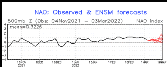
The NAO is negative, which is keeping the troughs from deepening very much. Also, the Bermuda high is set up a little further West, which means the flow is being pushed North quicker.
B.S. Geosciences, Professional Meteorology Concentration, Operational Emphasis
c/o 2015
Mississippi State University
@Norwoodwx
Leicester City FC Owner
-
Originally Posted by
TheRef
The NAO is negative, which is keeping the troughs from deepening very much. Also, the Bermuda high is set up a little further West, which means the flow is being pushed North quicker.
Any hint of a pattern change? I'm about to decide I'm going to have to go to OK to see a thunderstorm.
-
Talk about coming out of no where to blow up at the last minute:
-
Originally Posted by
starkvegasdawg
Any hint of a pattern change? I'm about to decide I'm going to have to go to OK to see a thunderstorm.
Sorry...brain was a little scrambled. we are in a positive NAO right now and it is expect to stay strongly positive.
B.S. Geosciences, Professional Meteorology Concentration, Operational Emphasis
c/o 2015
Mississippi State University
@Norwoodwx
Leicester City FC Owner
 Posting Permissions
- You may not post new threads
- You may not post replies
- You may not post attachments
- You may not edit your posts
-
Forum Rules
Disclaimer: Elitedawgs is a privately owned and operated forum that is managed by alumni of Mississippi State University. This website is in no way affiliated with the Mississippi State University, The Southeastern Conference (SEC) or the National Collegiate Athletic Association (NCAA). The views and opinions expressed herein are strictly those of the post author and may not reflect the views of other members of this forum or elitedawgs.com. The interactive nature of the elitedawgs.com forums makes it impossible for elitedawgs.com to assume responsibility for any of the content posted at this site. Ideas, thoughts, suggestion, comments, opinions, advice and observations made by participants at elitedawgs.com are not endorsed by elitedawgs.com
Elitedawgs: A Mississippi State Fan Forum, Mississippi State Football, Mississippi State Basketball, Mississippi State Baseball, Mississippi State Athletics. Mississippi State message board.


 Reply With Quote
